Quantcast
Channel: Abby Dotterer
Viewing all 40 articles
Browse latest View live

Ice Slough, Novelty on the Oregon Trail

$
0
0

As travelers on the Oregon Trail made their way west up the Sweetwater River valley, they found the grade even, but the road was often sandy and the winding river required many crossings.

Thirty miles or so before the trail left the valley to climb steeper stretches toward South Pass, emigrants forded the river yet another time, crossed a sandy, five-mile stretch and then came to a place many seem to have heard about in advance, though some doubted its existence.

This was Ice Slough, better known in the 1840s, 1850s and 1860s as Ice Springs.

“We were told we would come to ice spring this evening,” California-bound Thomas Eastin wrote July 14, 1849. “[W]e were told that we would find it in a low swampy place and that by digging a little below the surface we would find plenty of ice. The story appeared incredible and we paid no attention to it …”

But when Eastin’s party arrived they found other travelers already camped there—and, in fact, one or two were eating ice. “They took us to the place where they got it and with a spade we dug down about 12 inches beneath the surface and there sure enough found as pure ice as I ever saw about 10 inches thick,“ he wrote.

“We took up a bucket full. The story I fear will hardly be believed but it is nevertheless true.”

The Ice Slough is actually a small, subsurface tributary that drains into the Sweetwater. A variety of marsh grasses and related tufted marsh plants, known as sedges, form a patchwork of surface plant life. Water flowing underneath this peat-like vegetation freezes solid in the winter and remains frozen during the spring and early summer, thanks to the insulating peat.

Longtime trails historian Gregory Franzwa called the slough "one of those absolutely delightful interludes that somehow seemed to crop up just as the incessant slogging west was putting emigrants in the lowest of spirits."

“Here we found a great curiosity,” Mormon pioneer Norton Jacob wrote June 24, 1847. “[It] would seem that Vegetation & Frost had agreed to operate in copartnership, for in digging through a grassy turf to open a Spring we found plenty of Ice!”

Some travelers were prepared for a treat. “[W]e gathered several buckets full [of ice], Dr. William Thomas noted on June 16, 1849, “from which we have had mint julips in abundance.” Others could only remember past pleasures. “[W]ere it not for the absence of Brandy and mint, we might have had a beautiful Julep,” Henry Mann wrote when he passed Ice Slough two weeks later.

Because the place was such a novelty, many, many diarists wrote about it. In spring and early summer, some described a layer of peaty plant life floating on a layer of heavily alkaline water, under which lay the ice—clear, sweet, thick and good tasting.

“The Ice is found from 8 to 10 inches beneath the surface,” James Pritchard wrote on June 16, 1849. “There is from 4 to 6 inches of water above the Ice, and a turf or sod of grass apparently flo[at]ing on the water, upon which you can walk all over it. You can stand and Shake for 2 or 3 rods Square.” Many emigrants noted this shaking ground as they passed; some seemed to have seen similar shaking in bogs elsewhere.

“The water above the Ice is pretty strongly impregnated with Alkali,” Pritchard continued. “To get to the Ice you take a spade or Ax & cut away the sod & then strike down & cut it out in Square blocks. The Ice is clear & pure entirely free from any Alkali or other unpleasant taste. It is from 4 to 10 inches thick, and as good as any I ever cut from the streams in Kentucky,” he concluded.

As the summer weeks passed, emigrants described a layer between the ice and the peaty plant layer that was more and more like mud and less like clear--if alkaline--water. By late summer, many were unable to find any ice at all.

Steady use of the trail over three decades by what eventually totaled hundreds of thousands of people and millions of head of livestock seems to have changed the place as well.

In early July 1862, Oregon-bound Aaron Clough found a company of around 40 soldiers camped near the slough, and most likely near what had been a Pony Express station the year before until that operation was abandoned on completion of the transcontinental telegraph. The troops were probably members of the Ohio cavalry regiment that had arrived in the area a few weeks earlier to protect white travelers from raids by Indian warriors.

The place seemed less charming to Clough than it had to earlier diarists. “The slough at Ice springs is a spouty, swampy place, and is a dangerous place for stock. You can shake the ground for rods around by jumping up and down. If an ox gets stuck in the slough, it is almost impossible to get him out. … The water has a bad taste, a kind of sulphury or stone coal taste, like the water in the wells down on the Platte.”

Two weeks later, Randall Hewitt found the place littered with the carcasses of dead animals, killed, apparently, by the bad water. Buzzards were preying on the carrion. “It was a dirty, sandy, pestilential hole,” he wrote.

And the Army’s horses and mules had eaten nearly all the grass. “This escort had so far succeeded in just about denuding the country of what little feed there was, and was always sure to locate and occupy the best spots,” Hewitt wrote.

He felt tricked; it made him angry. “This delectable spot is named ‘Ice Spring’ by the guide books,” he noted. “It was said ice could be found by digging down about two feet. All traces of ice, if there had ever been any in the summer season, had disappeared before we got there. That ice story was a cold-blooded romance, put in the guide books to deceive.”

Today, the place is accessible only by crossing private land. Little ice is left, according to the National Park Service, since well over a century of trampling by wild horses and season-long grazing by livestock has so damaged the peaty layer that it offers no insulation to protect ice from melting.

Resources

Primary sources

  • Clough, Aaron. Diary. Aaron Clough Papers, 1860–1862. Microfilm 81, Oregon Historical Society of originals in possession of Mrs. J. M. Stamps, Portland, 1950. Richard Rieck transcription.
  • Eastin, Thomas N. Journal, 1 May to 19 August 1849. Manuscript, Filson Club, The Filson Historical Society, Louisville, Kentucky. Typescript.
  • Hewitt, Randall Henry. Across the Plains and Over the Divide: A Mule Train Journey East to West in 1862. New York: Argosy-Antiquarian, 1964.
  • Jacob, Norton. The Mormon Vanguard Brigade of 1847: Norton Jacob’s Record. Ed. by Ronald O. Barney. Logan, Utah: Utah State University Press, 2005.
  • Mann, Henry C. Diary. MSS C-F 130, Bancroft Library. Transcription by Richard L. Rieck.
  • Pritchard, James A. The Overland Diary of James A. Pritchard, from Kentucky to California in 1849. Ed. by Dale L. Morgan. Denver, Colo: Fred A. Rosenstock and The Old West Publishing Company, 1959.
  • Thomas, Dr. William L. Diary. Mss. CB 383:1, Bancroft Library. Transcription by Richard L. Rieck.

Secondary sources

  • Brown, Randy. Oregon-California Trails Association. WyoHistory.org offers special thanks to this historian for providing the diary entries used in this article.
  • Wyoming State Historic Preservation Office. “Ice Slough.” Emigrant Trails Throughout Wyoming. Accessed Feb. 16, 2017, at http://wyoshpo.state.wy.us/trailsdemo/iceslough256k.htm. The Franzwa quote and the Park Service information about the present lack of ice are from this article.

Illustrations

  • The photo of Ice Slough in summer is by Jonathan Wheeler, from Panoramio. Used with thanks. The winter photo is by Randy Brown, used with permission and thanks. The aerial photo is from Wyoming Tales and Trails. Used with thanks.

Yellowstone Park, Arnold Hague and the Birth of National Forests

$
0
0

No logging, no grazing—even no trespassing? The Yellowstone Timber Land Reserve, the first land to be set aside in what evolved into today’s National Forest system, had a distinctly different character from its successors. Here’s why.​

In 1883, when Arnold Hague arrived in Yellowstone, the 11-year-old national park was at a crossroads. The Northern Pacific Railroad had just completed its tracks across southern Montana, and railroad officials intended to market Yellowstone as a tourist pleasure resort. The conflict inherent in the national park idea—between promoting the enjoyment of natural wonders today and preserving them for tomorrow—was about to get its first big test.

Arnold Hague in Yellowstone

The U.S. Geological Survey (USGS) appointed Hague to head its efforts to study geysers, especially their relation to ancient volcanoes. Hague knew the subject well, having studied volcanoes in the Pacific states and Guatemala. He’d graduated from Yale, studied in Germany and worked in China. The son of a Baptist clergyman from an old New England family, Hague had become a scientist at an exciting time: Charles Darwin’s theories were expanding the frontiers of science just as European cultures were expanding to little-known lands.

Hague returned to the Yellowstone area for seven straight summers, with a growing field of study. He was well-traveled, with far-ranging interests. For example, he was the first to chronicle flecks of gold in the Stinkingwater Mining Region, at the confluence of Needle Creek and the South Fork of the Shoshone River southwest of present Cody, Wyo.

William F. “Buffalo Bill” Cody then patented these claims, and with Eastern investors sought for 20 years to develop mines in the district. The USGS in 1899 published Hague’s study—it covered more than 3,000 square miles—as a book and atlas titled “Geology of the Yellowstone National Park,” still praised by geologists almost a century later as one of the most in-depth Yellowstone studies ever performed.

But Hague’s interests extended beyond geology. In particular, he was concerned about protecting and preserving Yellowstone at a time when the park was threatened by expanding concessionaires, big-game hunters and railroads.

When these special interests sought inappropriate uses—hotels too close to natural features, lax enforcement of hunting regulations, or a railroad through the Lamar Valley—Hague fought against them. To influence federal policies, he was often joined by William Hallett Phillips, a Washington, D.C., lawyer appointed as a “special agent” for Yellowstone by the Interior Department.

Hague loved Yellowstone’s scenery: mountains, sunsets and wild animals. Having frequently followed elk trails, he believed that elk “have an appreciation of the picturesque and the grand.” But he rarely couched conservation arguments in sentimental terms. He frequently spoke of how both the Missouri and the Columbia river systems had their sources in Yellowstone National Park.

Pushing for an expanded Yellowstone

In an 1883 letter to U.S. Sen. George Graham Vest of Missouri, Hague noted that New York State’s quest to provide uniform water flow in the Hudson River necessitated complicated and expensive efforts to buy or control the Adirondack forests where the streams began. He suggested expanding Yellowstone’s borders to secure similar protections before private settlers arrived.

The idea of expanded park borders was not new. In 1882 Gen. Phillip Sheridan had proposed expanding the park 40 miles east and 10 miles south. George Bird Grinnell, the famed writer and conservation activist, highlighted the plan in his Forest and Stream magazine. Early in 1883, Sen. Vest sponsored an extension bill, which failed to pass. (A revised, successful bill improved park protections without changing its boundaries.) Hague’s scientific credentials and vast onsite knowledge could aid the cause.

Hague proposed expanding southward by eight rather than 10 miles (to the 44th parallel, near the north end of today’s Jackson Lake, thus excluding the Tetons) to avoid conflicts with potential mines or summer grazing lands. For similar reasons, his proposal for expansion went only 30 miles east. Briefly, he even flirted with rationalizing the park’s northern and western boundaries to match those of the Wyoming Territory.

Vest included Hague’s recommendations in four bills through the 1880s. They all failed, largely due to opposition from railroads wanting to build across the park’s northeast corner from Gardiner to Cooke City. But during the debates, Hague, Phillips of the Interior Department, Grinnell the conservationist writer and others also highlighted the wildlife benefits of an expanded preserve. These benefits took on increasing importance as concern rose through the 1880s about disappearing wildlife populations elsewhere in the West.

Advocates of expansion also started collecting their arguments about watersheds and habitat under the category of protecting forests. Forests, which provided the wildlife habitat and watershed protection, were at risk of being cleared for agriculture or cut down to provide timber for mines or charcoal for kilns. Without better protections for Yellowstone and its environs, Grinnell wrote, “Anyone was at liberty to cut down the forest, kill the game or carry away natural curiosities.”

Because of their work on behalf of Yellowstone, Hague and Phillips became the only two non-hunters ever elected full members of the influential Boone and Crockett Club. The elite sportsmen’s club, brainchild of Grinnell and Theodore Roosevelt, sought to influence federal policy on behalf of wildlife the same way the Audubon Society did for birds. The club represented the seed of Roosevelt’s conservation philosophy, which was to sprout so effectively during his presidency. In the club’s early days, one of the conservation leaders its members most admired was Arnold Hague.

Creation of the Yellowstone Timber Land Reserve

Other leaders at the time highlighted the nationwide benefits of forests, and the risks of wantonly cutting them down. Given how the clearcut forests of northern Wisconsin and Michigan had soon fallen prey to erosion and fire, should some forested lands in the West be held as public reservations?

Although in general the U.S. government wanted to give away the public domain to homesteaders, many congressmen at the time feared large corporations would assemble timber monopolies from formerly public lands. In this line of thinking, forest reserves could represent a Jeffersonian ideal. They could aid homesteaders by making small-scale timber cutting available to middle-class settlers, while ensuring watershed health.

Although bills with this goal failed in the 1880s, one did succeed in 1891. The key passage, known as Section 24, was a last-minute rider attached to a bill making broad reforms in public-land law.

Section 24 permitted the president to set aside timbered portions of the public domain as public reservations. However, it didn’t indicate what the purpose of these reservations should be, nor how they should be used, administered or funded.

President Benjamin Harrison signed the bill on March 3, 1891. Late the following week, Hague and Phillips discovered Section 24. Hague realized that it could accomplish his aims of expanding Yellowstone’s boundaries. On March 16, he took the idea to Secretary of the Interior John W. Noble. Noble asked Hague and Phillips to draft a proclamation to create the first Forest Reserve with the exact same boundaries Hague had proposed to Sen. Vest eight years earlier. President Harrison signed the proclamation on March 30, 1891, creating the 1.2-million-acre Yellowstone Timber Land Reserve.

Why isn’t Hague better known as its creator? Because he understood politics and was more interested in results than fame. On April 4, he wrote to Grinnell with information to be used in a Forest and Stream editorial lauding what would become known as the Forest Reserve Act of 1891. Hague wrote, “[Y]ou had better give the Secretary of the Interior a little taffy for his seeing the necessity for this thing.” Grinnell obliged; although his article mentioned Hague, it concluded that “too much credit cannot be given” to Noble.

This was the world’s first forest reserve to be set aside by a democratic government. But it wasn’t really a victory for “forestry” as we know it today. Instead, Hague and his allies often described the reserve as, effectively, an adjunct to the world’s first national park.

As Grinnell wrote, since people would be prohibited from living there, it would be easy later to transfer these lands to the park. In an 1898 essay (reprinted in the 1903 book Our National Parks), famed naturalist John Muir wrote that Yellowstone “was to all intents and purposes enlarged” by the reserve. His interpretation, however, proved overly optimistic.

Failures of the early forest reserves

In the same way that the U.S. Constitution arose out of years of frustration with the Articles of Confederation—an early attempt to translate idealistic principles to governance, with numerous practical failures—so too did the U.S. Forest Service arise out of the Forest Reserves. The period 1891–1905 saw a long struggle to effectively articulate a vision and management philosophy for administering federal forest lands.

After creating the Yellowstone Timber Land Reserve, President Harrison established additional forest reserves in Colorado, New Mexico and Oregon. He eventually preserved 13 million acres, and his successor, Grover Cleveland, added 25 million more.

But though Congress, perhaps unintentionally, had ceded to the president the authority to create reserves, it refused to decide how to manage them. And without guidance from Congress, no activity was allowed at all in the reserves. No homesteading, no logging, no mining, no grazing, no hunting—no trespassing! “Trespassing on the public lands within these forest reserves will not be tolerated under any pretext,” read one government communication. These lands were reserved from use, and so nobody was allowed onto them.

Unsurprisingly, the Forest Reserve Act didn’t provide any budget to manage the reserves, or suggest any penalties for trespass or depredations, so in most reserves the regulations were toothless. But the Yellowstone reserve was placed under the authority of the Army, which was then managing the adjacent national park, and Army officials could extend ranger patrols to the east and south.

The following year the Army built a ranger cabin at Polecat Creek, near today’s Flagg Ranch south of the park’s boundary. But by 1894 the superintendent was complaining that the added regions were too remote, too large, too rugged, and too frequented by hunting parties to be effectively policed with his limited manpower. Likewise, an official report in 1897 noted that at least 100 prospectors and 25 ranchers were spending the summer in the forest reserve, all of them hunting, in areas too remote to patrol without increased budgets.

In other regions, clashes over forest reserve policies were more severe. In Colorado, homesteaders and stockgrowers expressed outrage at the loss of their “rights.” They also feared that the far-off Interior Department might sell off timber to an Eastern monopolist, a result that would have been the opposite of the law’s intention.

In Oregon, opposition to the vast Cascade Range Forest Reserve arose primarily from sheep ranchers and miners denied access to grazing or mining on public lands. Ironically, the fate of timber in the reserves was a lesser issue—perhaps because the remote, high-elevation stands were not seen as commercially viable, or perhaps because large timber companies hoped that federal regulation would stabilize the market and reduce competition.

In a further irony, the authors of Section 24 had likely intended to permit grazing and small-scale logging on the reserves. But the section’s confusing language and lack of follow-up led to public opposition to the law.

The National Forest Commission

To remedy the stalemate, federal leaders asked the National Academy of Sciences to appoint a blue-ribbon commission to help resolve the fate of the reserves. Critics of the commission—such as Bernhard Fernow, who ran the advisory-only Division of Forestry in the federal Department of Agriculture—said that its summer-long tour of Western forests would be little more than a junket. But its fans hoped that it could do what Congress had yet failed to: figure out a policy for forest conservation, and spur legislation accomplishing that policy.

The commission’s chair was botanist Charles Sprague Sargent, head of Harvard University’s Arnold Arboretum and publisher of Garden and Forest magazine. Its secretary was a young forestry graduate—at 31, half the average age of the other commissioners—named Gifford Pinchot. Also on board: Gen. Henry L. Abbot of the U.S. Army Corps of Engineers, a veteran of Western railroad surveys; Alexander Agassiz, curator at the Harvard Museum of Comparative Zoology; Yale professor William H. Brewer, who was also California’s state botanist; John Muir, in an unofficial advisory capacity since he wasn’t the sort of person to join committees; and Arnold Hague.

Hague’s reputation and experience made him one of the nation’s leading experts on forest reserves. In fact, Hague and Pinchot were assigned to make a preliminary report and recommendation before the commission began its tour.

In 1896, the commissioners toured the Black Hills, Yellowstone, northwestern Montana, Oregon’s Cascades, California’s Sierra, the Grand Canyon, New Mexico and Colorado. They traveled mostly by train, and not always together: Pinchot took a side-trip to examine Montana’s Bitterroot Range, and Muir took a long break to visit Alaska. They returned to the East with numerous recommendations for new forest reserves.

But they still had little agreement on how to manage the reserves. For example, Pinchot believed in the emerging discipline of forestry, maximizing the efficiency of timber production as if trees were agricultural crops capable of a sustained yield. In contrast to that resource-based approach, Sargent and Muir tended to think of trees and forests in more holistic, perhaps more sentimental, terms. Sargent and Abbot favored military management; Pinchot, Brewer and Hague argued for civilian control.

Muir was fanatically opposed to sheep grazing (he memorably referred to sheep as “hoofed locusts”). Sargent expected political opposition to whatever they recommended; Pinchot fulminated at Sargent’s lack of political will.

The result: The commission recommended 13 new reserves totaling 21 million acres. They hurried through the recommendation process so that President Cleveland could create the reserves in the month before he left office. Cleveland issued the proclamation creating the new reserves on Washington’s Birthday, February 22, 1897.

Among the newly set-aside lands was the 892,440-acre Teton Forest Reserve south of Yellowstone. Hague’s original Yellowstone Timber Land Reserve remained intact, with its lands 30 miles east and eight miles south of the park boundary. But the Teton Reserve added another 15–20 miles southward, including the Teton Range and the northern half of Jackson Hole.

Problems and promise

That recommendation demonstrated both the problems and the promise of the Forest Reserve system. The problems: Hague had withheld the Teton Reserve lands from the original Yellowstone Timber Land Reserve because he knew that demands for grazing and mineral development made them poor candidates to become part of Yellowstone National Park. Furthermore, given the combination of the open lands of Jackson Hole, the effects of past forest fires and the lands above timberline, perhaps only 40 percent of the Teton Forest Reserve was actually forested.

Worst of all, as of the proclamation, the commission still had not decided the purpose of forest reserves. So these lands, like the 12 other new reserves, became off limits to use. As a result, Cleveland’s proclamation created a serious backlash in Western states.

Congressmen quickly drafted language restoring all forest reserves to the public domain—and attached it as a rider to the basic bill funding the entire government. Cleveland, on his last day in office, used a pocket veto to kill the bill, threatening a government shutdown. The new president, William McKinley, had to call an extra session of Congress. Now the entire forest movement was in jeopardy.

Amid intense lobbying on all sides, Congress found a compromise. First, it suspended the 13 new reserves for nine months, allowing thousands of acres to be transferred to private ownership. Second, it established purposes for the reserves, and gave the Interior Department authority to regulate their use, in a law now often known as the Forest Management Act (or Organic Act) of 1897.

As interpreted by the increasingly powerful Gifford Pinchot, permissible uses included timber harvests, dams, and grazing by cattle and (much to Muir’s dissatisfaction) sheep. With uses permitted, Western commercial interests became increasingly willing to accept new reserve acreages.

In 1902, the Yellowstone and Teton Reserves were greatly expanded. (They were also reorganized, with lands south of the park consolidated in the Teton Forest Reserve and lands east of the park renamed the Yellowstone Forest Reserve. In subsequent years, the lands would be repeatedly reorganized and renamed.)

Yet the fact that reserves were no longer extensions of national parks also demonstrated their potential. Through the first decade of the new century, after Roosevelt ascended to the presidency in 1901, Roosevelt and Pinchot continued to clarify the utilitarian philosophy of the “multiple use” system—and greatly expanded the nationwide scope of protected lands.

In 1907, to reflect the fact that these lands were no longer “reserved” from use, the reserves were renamed national forests. America found a vital role for these forests, complementary to that of national parks.

In today’s Shoshone and Bridger-Teton National Forests, which administer the lands Hague once arranged to be set aside, tourist demands are much reduced compared to the adjacent national park—and so are regulations on hunting, fishing, camping, hiking, grazing, and logging. But they remain public lands, protected from residential or commercial development, regulated to promote watershed and ecosystem health, and accessible to all.

They play essential roles in the lives of Wyomingites and in the ecosystem of greater Yellowstone. The process of fleshing out those roles began with Arnold Hague.

Resources

Primary Sources

Secondary Sources

Archives and collections

  • The Park County Historical Archives in Cody has a Shoshone National Forest History file with several clippings and memoirs, including a discussion of Arnold Hague on the Stinkingwater.
  • Hague and others were mentioned in Wyoming newspapers; you can search on their names at http://newspapers.wyo.gov/.

For further reading

  • A Plan to Save the Forests.” The Century Illustrated Monthly Magazine. Volume 49, pp. 626-634. An 1895 symposium on the reserves, with contributions from Sargent, Pinchot, Muir, Roosevelt, Yellowstone superintendent George Anderson, and others.
  • Allan, Esther B. “History of Teton National Forest.” Jackson, Wyo.: Bridger-Teton National Forest, 1973, pp. 107-120, accessed May 22, 2017 at https://www.fs.usda.gov/Internet/FSE_DOCUMENTS/fseprd534131.pdf. Many great details and reminiscences of Jackson Hole and the Teton Forest Reserve, although weak on context.
  • Brandegee, Townshend Stith. The Teton and Yellowstone Park (southern Part) Forest Reserves, U.S. Government Printing Office, 1899. A descriptive account, by a botanist assessing timber.
  • Cleveland, Grover. "Proclamation 394—Withdrawl [sic] of Lands for the Teton Forest Reserve, Wyoming." February 22, 1897. Online by Gerhard Peters and John T. Woolley, The American Presidency Project, accessed May 22, 2017 at http://www.presidency.ucsb.edu/ws/?pid=70861.
  • Ise, John. The United States Forest Policy. New Haven, Conn.: Yale University Press, 1920.
  • Miller, Char. Gifford Pinchot and the Making of Modern Environmentalism. Washington, D.C.: Island Press, 2001.
  • Steen, Harold K.. The U.S. Forest Service: A History, Seattle: University of Washington Press, 2004.
  • Worster, Donald. A Passion for Nature: The Life of John Muir. New York: Oxford University Press, 2008.

Illustrations

  • The photo of Eagle Creek Meadows in the Shoshone National Forest is by Ralph Maughan, from Panoramio. Used with thanks.
  • The photo of U.S. Senator George Vest is from the Biographical Directory of the US Congress. Used with thanks.
  • The 1892 General Land Office map of the Yellowstone Timber Land Reserve is from Wyoming Places. Used with permission and thanks.
  • The drawing of Arnold Hague, originally published in Appletons' Cyclopædia of American Biography, 1892, is from Wikimedia. Used with thanks.
  • The photo of Charles Sprague Sargent, first published in The World’s Work, 1901, is from Wikimedia. Used with thanks.
  • The 1900 GLO map of the Teton Forest Preserve is from Wyoming Places. Used with permission and thanks.
  • The 1902 photo of John Muir is from the Library of Congress. Used with thanks.
  • The 1907 photo of President Theodore Roosevelt and Gifford Pinchot on the steamer Mississippi is from the Library of Congress. Used with thanks.

Moon Shadows over Wyoming: The Solar Eclipses of 1878, 1889 and 1918

$
0
0

In the summer of 1878, William O. “Billy” Owen was working with a surveying crew high in the Medicine Bow Mountains, about 36 miles west of Laramie, Wyoming Territory. “Over that vast forest,” he later wrote, “the moon’s shadow was advancing with a speed and rush that almost took one’s breath.” This was the total solar eclipse of July 29, 1878.

“It was terrifying, appalling,” Owen’s account continues, “and yet possessed a majestic grandeur and fascination that only one who has seen it can appreciate.”

Worldwide, solar eclipses occur relatively often, at a rate of two to five per year. In a solar eclipse, the moon passes between the earth and the sun, sometimes blocking part of its light and at other times, all. A complete blockage is a total eclipse, and the zone of the earth traversed by the moon’s shadow is called the path of totality. The width, length and route of the path all differ from one eclipse to the next.

“Totality” is the brief period of darkness on Earth when the sun is completely obscured. Totality can last less than one minute or more than seven. During totality, astronomers have a unique opportunity to study the “night” sky around the sun. Because the light of the sun itself is blocked, they can also observe the corona—the sun’s outer atmosphere—otherwise invisible.

Besides the 1878 eclipse observed by Owen and his party, two other total solar eclipses since territorial times crossed present Wyoming before 2017—in 1889 and 1918. These were important opportunities for astronomers with enough personal or institutional means to travel to a choice location and to pay for shipping the necessary equipment. In two of the three eclipses, the totality paths crossed the line of the Union Pacific railroad in Wyoming, greatly simplifying all logistics.


The 1878 eclipse

The path of totality of the July 29, 1878, eclipse crossed most of Wyoming Territory in a swath from northwest to southeast. It was 191 kilometers wide—about 118 miles. Darkness on the centerline of the path lasted three minutes, 11 seconds.

Wyoming residents watched the eclipse through smoked glass, as did Owen and his companions. They also viewed part of the eclipse using their Burt’s solar compass, a large brass surveyor’s device with a mirror and other attachments that allow the user to find true north using the angle of the sun, instead of magnetism.

Such a simple setup was not sufficient for the professional astronomers who spent ten days or more in Wyoming Territory, however. They were there to gather data available only during totality and had to work fast and with the best possible tools.

The inventor Thomas Edison traveled with a party that set up a temporary observatory near Rawlins, Wyo., attracting substantial local publicity. Edison was eager to test his new tasimeter, a highly sensitive heat-measuring device. The July 30, 1878, Laramie Daily Sentinel reported that seven experts, some with their wives as assistants, were working at the observatory. Henry Draper of New York, director of the Rawlins observatory, was the most eminent astronomer in the party.

Draper was a pioneer, perhaps the first, in the young science of astrophotography. He planned to photograph the corona, and delegated other important observations to his colleagues. Draper reported their findings in the September 1878 American Journal of Science and Arts.

The scientists hauled nearly a ton of equipment, including at least four telescopes and accessories plus chemicals needed for the wet-plate collodion photographic process. The best system available at the time, it required the glass plate to be coated, exposed and developed, usually in a portable darkroom, all within about 15 minutes.

At Separation, a railroad station 14 miles west of Rawlins, the Canadian-American astronomer, Simon Newcomb, was in charge of a small party, one of two from the U.S. Naval Observatory in Washington, D.C. Newcomb was director of the Nautical Almanac, which provides astronomical data for celestial navigation and is still published by the U.S. Navy.

There was nowhere to sleep at Separation except in tents; the stationmaster’s wife cooked for the party. On July 24, Newcomb traveled to Rawlins to meet British astronomer J. Norman Lockyer, founding editor of the prestigious science journal, Nature. Lockyer had led eclipse expeditions to Sicily in 1870 and India in 1871, but this time was traveling alone and intended to assist Newcomb and the other American astronomers. After spending a night in the Separation depot, Lockyer returned to Rawlins to stay at the Railroad Hotel, quarters for the Draper expedition.

At Creston, the station 12 miles west of Separation, the second party from the U.S. Naval Observatory, led by William Harkness, enjoyed more conveniences than did Newcomb and his assistants.

Harkness, Otis F. Robinson, Alvan G. Clark and a few others slept in the railroad car that had delivered their equipment, and enjoyed the cooking services of soldiers sent from Fort Steele, where the railroad crossed the North Platte River, 41 miles to the east. The Harkness party’s temporary observatory had a canvas roof for quick removal before observations.

Harkness and his party spent the days leading up to the eclipse rehearsing, and testing equipment for the big event, down to the tiniest details. To establish their precise latitude, Harkness used a sextant and artificial horizon—a basin of mercury under glass. To find their longitude, Harkness received telegraph signals at the Creston station, helping him compare local time with the time at locations where longitude was already known, in Utah, Pennsylvania and Washington D.C.

At the observation point of an eclipse, knowledge of the exact latitude and longitude enabled astronomers to compare the predicted path of the moon’s orbit with its actual path, and therefore to make needed corrections.

Alvan Clark was a maker of fine scientific instruments. The company Alvan Clark and Sons had received a medal from the French Academy of Sciences for making huge telescope lenses, many of which had been installed in the best American telescopes, including some shipped to Wyoming for the eclipse.

At Creston, Alvan Clark was to photograph the corona. During the party’s many drills, Clark inserted a plate into his camera, exposed it, removed it and inserted a new plate. Otis Robinson tested a polariscope, which might offer clues to the nature of the corona—did it shine by its own light, or was it just reflected somehow from the sun? To study the chemical composition of the corona, Harkness practiced with his spectroscope, which, by isolating different parts of a star’s spectrum, made it possible to determine the different chemical elements in the star.

The men drilled from 7:30 a.m. until 10:00 p.m., with breaks for lunch, supper and an evening walk. All the expeditions performed similar drills, day after day, to perfect their routine so no time would be wasted during the brief totality.

Another American astronomer, James C. Watson from the University of Michigan at Ann Arbor, traveled with his wife and set up a Clark and Sons telescope near Rawlins. Like Lockyer, Watson and his wife stayed at the Railroad Hotel.

Watson had high hopes that during totality he would be able to see Vulcan, supposedly a new planet orbiting between the sun and Mercury. The existence of Vulcan had been proposed to account for a known disturbance in Mercury’s motions.

The Sentinel captured the excitement of the scene near Rawlins in the days leading up to the eclipse. The visiting astronomers, the Sentinel reported, were kind and courteous. They “furnished a rare opportunity to us frontier residents to enjoy some of the wonders of science … and they never tired of showing and explaining … the use of the instruments, and showing [curious citizens] the wonders of the heavens through their glasses.”

The visitors, too, appreciated the treatment they received. Draper later wrote, “Of the citizens of Rawlins it is only necessary to say that we never even put the lock on the door of the Observatory, and not a thing was disturbed or misplaced during our ten days of residence, though we had many visitors.”

Lockyer, Newcomb and others reported their findings in or were interviewed by The British Journal of Photography, Scientific American, The Washington Post, the Courier-Journal of Louisville, Ky., the New-York Tribune, the New-York Daily Tribune and the American Catholic Quarterly Review.

Lockyer reported that he was convinced that Watson had, in fact, seen Vulcan. It would be nearly 37 years before Albert Einstein’s general theory of relativity would account for this disturbance, and rule out the existence of Vulcan.

The weather was clear for all observers.

The 1889 eclipse

The path of the total eclipse of Jan. 1, 1889, crossed just a small piece of Wyoming—across the far northwest corner of Yellowstone Park. Totality on the centerline lasted two minutes, 17 seconds, and was 175 kilometers, or about 108 miles, wide.

Apparently, few astronomers visited Wyoming Territory for this eclipse, probably because transportation to Yellowstone was still difficult. Besides, there were plenty of other good locations in the country for viewing totality.

The Cheyenne Daily Leader reported on Jan. 6, 1889, “The eclipse was seven eighths total here. The sky was perfectly clear and darkness settled down as on a cloudy day. The air became decidedly cooler. Observations were taken by Prof. Garrard of Kentucky and Prof. John Harrington and Dr. Glover of the Thirty Society of this city.”

“Hundreds of Laramie people viewed the eclipse through smoked glass,” reported TheLaramie Boomerang on Jan. 2, 1889. “During the [partial] obscuration Venus could be plainly seen.”

The 1918 eclipse

Totality for the June 8, 1918, eclipse lasted two minutes, 23 seconds, and the path was 112 kilometers (about 69 miles) wide, crossing the southeast corner of Wyoming, including Rock Springs and Green River.

At least six well-known astronomers visited Wyoming for this eclipse. The Green River Star reported on June 14, 1918, that the town “probably never again will … see so many great astronomers at any one time. Professors Frost, Hale, Barnard, Ellerman, Parkhurst, Anderson and many others have been located here for some time.”

The Star goes on to describe the “wonderful clock-driven heliostat” owned by the Yerkes Observatory, of the University of Chicago. The heliostat—a mirror geared to a clock in order to continue reflecting the sun’s light at a single target as the sun moves through the day—threw the sun’s rays into a horizontal telescope and kept the light “steadily in one direction, without deviation for any length of time,” The Star reported.

Complete with “gigantic cameras and spectrographs,” the Yerkes telescope was set up near a local outcrop known as Teapot Rock—not to be confused with the better-known rock in central Wyoming that gave its name to the Teapot Dome oilfield.

The Yerkes party, a total of 16 observers, included Edwin Brant Frost, co-editor of the international Astrophysical Journal and professor of astrophysics at the Yerkes Observatory, as well as Edward Emerson Barnard, whom Isaac Asimov described in 1975 as “perhaps the keenest-eyed astronomer in history.”

The September 1918 Monthly Evening Sky Map published a photograph taken by Barnard of solar prominences, one of them more than 47,000 miles high. A solar prominence is an incandescent stream of protons, extending beyond the corona’s normal edge.

A party from the Mount Wilson Solar Observatory near Los Angeles, Calif., was led by George Ellery Hale. Hale was a graduate of the Massachusetts Institute of Technology and established the Astrophysical Journal in 1895. He had been associate professor of astrophysics at the University of Chicago and had obtained all the funding for the Yerkes Observatory. In 1904, Hale founded and also raised money for the Mount Wilson observatory, and became its director.

Like the Yerkes party, the Mount Wilson expedition set up its temporary base near Green River. In addition to hauling the 30-inch mirror from their prized Snow telescope—a permanent fixture at Mount Wilson—the scientists brought three cameras and three spectrographs. A spectrograph is a device for isolating a portion of a star’s spectrum, and recording this data with a camera.

Clearer skies than in Illinois

Jacob Kunz and Joel Stebbins, a two-man expedition from the University of Illinois Observatory at Urbana, set up their equipment about two miles south of Rock Springs, Wyo. Their account of the expedition and its results, published in the December 1918 Popular Astronomy, is the most extensive and least technical of all the visiting astronomers’ reports.

To measure the brightness of the corona, Kunz and Stebbins hauled more than 400 pounds of equipment, including electric lamps, batteries and galvanometers. A galvanometer measures or detects a small electric current by movements of a coil or a magnetic needle. Kunz and Stebbins achieved their goal of comparing the corona with light sources of known strength, including a candle and an electric light bulb.

“Before leaving Urbana where smoke has been a nuisance for a dozen years,” Kunz and Stebbins reported, “we vowed that with several hundred miles of eclipse track to choose from we would make sure that this trouble at least would be left at home.” Except for two coal mines about a mile away, in Wyoming they were “as secluded as though we had been far from any town.”

A local contractor, Mr. Kellogg, built the shelter that was their temporary observatory, and Kunz and Stebbins also recruited two local assistants, “Messrs. Homer Coté and Paul Freeman, two mining surveyors.”

The performance of their equipment was superb. “Being far from traffic, the galvanometers were perfectly steady, and the dry air of Wyoming eliminated troubles with electrical insulation.” Their report continues, “Neither of us had ever seen anything like it before, and it remained for our cozy little hut in the desert to demonstrate what a model laboratory should be.”

They described in detail the partly cloudy sky, and the suspense they endured right up until two minutes before totality. They were the luckiest of the 1918 parties: At the critical time, thin clouds had covered the eclipse near the Green River observatories.

The June 8, 1918, Laramie Republican noted, “[O]ne may look at … [the eclipse] through a pinhole in a piece of paper or through a dark glass … easily smoked by a candle or oil lamp.” The Republican cautioned, “One must be very careful to have the glass so dark that the sun does not dazzle the eye at all.”

Kunz and Stebbins noted in their Popular Astronomy article that although Stebbins had witnessed two other total eclipses, he “was quite unprepared for the weird effect of the ashy light on the desert landscape shortly before totality, and for the spectrum colors in the clouds about the sun as they were breaking at the last minute.”

As in 1878, visitors were pleased to find the inhabitants so friendly. “We received uniform courtesy and aid from the people of Rock Springs,” wrote Kunz and Stebbins, “and in particular enjoyed the hospitality of the mayor, Dr. E. S. Lauzer.”

Except for the wind, which can disturb the precision of astronomical instruments, Wyoming is an ideal place to observe a solar eclipse. High altitude, fair weather and clear air, far from polluting population centers yet near sources of food, shelter and building services, attracted experts to these early eclipses from the United States, Great Britain and Europe. In turn, their discoveries advanced the science of astronomy worldwide.

Resources

Primary Sources

Secondary Sources

Illustrations

Alpine Lives of Ancient People: High-mountain Archeology in Wyoming

$
0
0

In recent years, melting ice and mountain fires have revealed ancient human presence at elevations above 8,000 feet in northwestern Wyoming. Findings of archaeologists over the past decade, including a large, prehistoric village site near Dubois, Wyo., indicate humans lived high in the mountains as long as 10,000 years ago.

“We've constructed a fiction that mountains/wilderness are landscapes that have had only a limited, transient human presence,” notes Lawrence Todd, Colorado State University professor emeritus of anthropology. In reality, however, “the archaeological record indicates that native peoples have been a key component of mountain ecosystems and mountains have been important components of human socio-cultural systems.”

Five teams of professional archaeologists from three universities, together with amateur explorers, have studied areas in the Wind River and Absaroka ranges and in the Bridger-Teton National Forest for nearly 50 years. Much more recently, a combination of computer modeling, forest fires and melting ice have led to significant discoveries about ancient, high-mountain people. 

Probably summer residents, these people lived in conical timber lodges, sometimes referred to as wickiups. They may have eaten fish, and hunted mountain sheep, deer, elk and smaller mammals. Plant foods were also available at high altitudes, everything from roots to greens, berries and pine nuts.

Early high-altitude explorations

In the 1969 and 1970 field seasons, Colorado State University undergraduates Vaughn Hadenfeldt and Phillip Foss, Jr., found 19 prehistoric high-altitude sites, most above 10,000 feet, in two different drainages in the southern Wind River Mountains. Foss and Hadenfeldt wrote a 100-page term paper on the project, but their findings were not otherwise recorded at the time. Theirs was the first high-altitude archaeological survey in Wyoming, and one of the first in the Rocky Mountains.

George C. Frison, professor emeritus of anthropology at the University of Wyoming, conducted an archaeological survey of the Bridger-Teton National Forest in field season 1974. Frison and his team found 33 sites including two fire pits, plus soapstone—more formally known as steatite—vessels, stone choppers and more than two dozen styles of projectile points.

The Burnt Wickiup Site and High Rise Village

Dubois, Wyo., outfitters and avocational archaeologists Tory and Meredith Taylor found a wickiup—a conical dwelling made of tree branches and barkon the east side of the Wind River Mountains in the late 1990s. The Taylors found no artifacts in or around the wickiup, but after a forest fire destroyed it a few years later, they recovered artifacts of chipped stone and of ground stone. These had been exposed by the destruction of “pine duff”—decayed pine needles and other organic matter on the forest floor. In 2003, the Taylors showed the site to Richard Adams, now retired from the Office of the Wyoming State Archaeologist and an adjunct instructor at Colorado State University, in Fort Collins. Adams and the Taylors named it the Burnt Wickiup Site.

With this and other recent fire-related discoveries in mind, Adams, along with the Taylors and others, began investigating burned areas in the mountains of northwest Wyoming. In August 2006, they found a major prehistoric village in the northern Wind River Range near Dubois. More than 70 circular flat spots, dug into slopes that rise as steeply as 20 degrees, and fortified on the downhill side, were subsequently documented at this location. On a 20-degree slope, a downhill step of one foot in length is a drop of four and one-half inches.

The dirt circles, or lodge pads, were probably supports for wooden lodges such as wickiups. Four pads still had traces of these structures.

“Trudging up and down this slope made me realize that the site was as tall as a 30-story apartment [building],” Adams writes. “By any measure, a 30-story building is a high rise, hence … [we named it] High Rise Village.”

In subsequent field seasons, from 2007 through 2010, the group found five more similar villages, all in the Wind River Range. In 2015, Adams and Connor Johnen, a master’s degree student at the University of Wyoming, revisited the area explored by Hadenfeldt and Foss. They photographed some of the sites, drew site maps and completed site forms. They also found and recorded 11 new sites, but no villages.

Computer modeling discoveries

Matthew Stirn, director of archaeological research at the Jackson Hole Historical Society and Museum, in Jackson, Wyo., joined Adams’ team in 2008, and developed a computer model to predict the locations of other high-altitude sites. Features included in the model were altitude, slope, sun exposure, warmth and possible vegetation. In field seasons 2010 and 2011, Stirn and his team found more than 50 new sites, including 13 alpine villages similar to High Rise Village.

“It was thrilling to put so much effort into a project and to have it work out so successfully,” Stirn writes. “That [first] summer of exploration and discovery was one of my most memorable and exciting in a decade of alpine archaeology.”

The Greybull River Sustainable Landscape Ecology Project (GRSLE)

Since 2002, meanwhile, Lawrence Todd of CSU has been documenting sites and artifacts in the Absaroka Mountains, north of the Wind River Range. Wildfires from 2006 through 2011 revealed many new sites and artifacts. For example, after the Little Venus Fire of July and August 2006, Todd and his teams recorded about 1,600 percent more surface artifacts in the area. They also found a greater diversity of objects: ceramics, metal, glass beads, pieces of obsidian and faunal remains, like animal bones.

After the 2011 Norton Point Fire north of Dubois, Todd and his team coded more than 17,000 pieces of chipped stone in one 1,052-acre area. When ancient people made projectile points or other stone tools, they also left hundreds or thousands of stone chips behind, as well as the finished artifacts. Todd estimates that these pieces represent less than half the materials exposed by that fire in their survey area.

High-altitude subsistence

Intense summer heat, which often dries out the lower elevations in Wyoming by midsummer and causes wildlife to seek cooler, moister environments, also drove game of long ago high into the grass-rich mountain habitat. Ancient hunters almost certainly followed, as shown by drive lines and corrals for herding mountain sheep, plus stone blinds and other evidence of large-mammal harvesting found decades ago in high elevations. But the artifacts tell only part of the story.

Most or all the villages in the Wind River Mountains are near stands of whitebark pine trees, whose abundant, nutritious nuts may have been a staple for the people who lived there. Adams and his associate, Rhoda M. Schantz, have calculated that 10 kilograms of unshelled pine nuts, about 3,000 cones’ worth, is the meat equivalent of a large pronghorn antelope. Other likely plant foods were the biscuitroot, the sego lily bulb and yampah root. The presence of metates and manos—a mortar/pestle set of tools—also suggest the processing of various plant foods.

Site and artifact ages

Radiocarbon dates from High Rise Village range from about 4,500 years before the present (BP) to about 150 years ago—around the time the Union Pacific Railroad was built across Wyoming. The older dates might not reflect human occupation, because these dates correspond to the age of nearby stands of whitebark pine, which later occupants may have burned for firewood. The likelier High Rise dates are 2,800 to 150 BP, placing these sites and artifacts in the archaeological periods known as the Late Plains Archaic through the mid-1800s. However, some items suggest humans lived in the area much earlier. Todd and Tory Taylor have both found Folsom-era projectile points dating from approximately 10,000 or 10,500 years BP at high altitudes.

Ice-patch archaeology

“Because of global warming, high alpine ice is melting at an unprecedented rate,” writes Stirn. “[A]s a result, [it] is exposing cultural and biological material that has been encased and preserved for thousands or even tens of thousands of years.”

Less than one percent of all artifacts found in Wyoming have been found because of melting ice. However, these artifacts are often so well preserved that archaeologists can sometimes learn more from a single ice-patch artifact than from one discovered elsewhere.

“[M]ost tools used by past cultures were probably made of organic material,” Stirn notes, “and haven’t survived over the years. So, when we do find an ice-patch artifact it is especially exciting because it provides a rare glimpse into the past that we don’t normally get to witness.” Stirn explains that this is one reason archaeologists “are particularly alarmed at the extent that ice in Wyoming is disappearing, along with the fragile archaeological information preserved within.”

For the past four years, Stirn and Rebecca Sgouros, director of community archaeology for the Jackson Hole Archaeology Initiative, have been exploring ice patches in the Grand Tetons as part of the Teton Archaeological Project. In field season 2014, they found a stave-cut segment of whitebark pine, radiocarbon dated to approximately 2,700 BP, shown in the second photo in this article. A stave-cut piece of wood is cut out of a tree along the grain.

Dr. Craig M. Lee, of the Institute of Arctic and Alpine Research (INSTAAR) at the University of Colorado in Boulder, has been studying ice patches in the Greater Yellowstone Area for more than a decade. The Greater Yellowstone Area, about 24,000 square miles, includes Yellowstone National Park and five national forests surrounding it, Grand Teton National Park, most of the country along Idaho’s eastern border and the mountainous south-central portion of a small part of southern Montana, including the Gallatin and Absaroka mountain ranges.

Lee has documented about 25 organic artifacts, including wooden shafts and shaft fragments and one object of plaited leather and bark. An atlatl dart, about 10,300 years old, which Lee found in Wyoming, is the oldest known ice-patch artifact in the world. Atlatls were ancient dart-throwing devices used to kill game.

High-altitude environments “were totally and completely populated,” Lee notes, “and ice-patch recoveries help to back up, and to overcome our ignorance of, tribal oral histories about how the ancestors of today’s Native Americans lived up high.”

Through the Greybull River project in the Absaroka Range, Todd began researching ice patches in 2014. Beginning in 2015, Todd’s group studied 11 ice patches identified earlier by Lee, who used a computer model to predict locations likely to contain ancient perishable artifacts.

Todd and his team found thousands of items. These include two wooden bows and nearly 20,000 pieces of chipped stone in an area of about 430 acres. At about 10,350 feet elevation, they found the highest stone circle habitation sites in the GYA. In 2015 and 2016, Todd’s team found 7,000 pieces of chipped stone in an approximately 3 percent sample of the surface of one site that lies between 9,600 and 10,500 feet.

The occupants

Shoshone probably lived in the Absarokas and at High Rise Village and similar sites in the Wind River Mountains. Artifacts found at High Rise Village and associated with the mountain Shoshone include steatite bowls, which women used and passed down to their daughters. Another tool associated with women is the teshoa, made of stone and used as a knife and also for harvesting roots and other digging. Early white explorers observing the Shoshone noticed only women using the teshoa, but archaeologists don’t know whether it was actually a tool used exclusively by women.

Projectile points associated with the Shoshone and found at High Rise Village are of the desert tri-notch, cottonwood triangular and rose-spring style. Archaeologists have also found steatite pipes, beads and atlatl weights at other locations in Wyoming.

“None of those artifacts by themselves necessarily indicates Shoshone,” writes Stirn, “but if they are all found at one site we can be a little more certain.”

The ancient mountain Shoshone are probably the ancestors of the small groups of Shoshone who lived in the mountains of northwest Wyoming and who, in more recent times, became known as the Sheepeaters.

More modern migration

Ancestors of modern-day Northern Paiute, Ute and Shoshone are referred to as Numic speakers. Archaeologists generally hypothesize that some Numic speakers occupied, or at least migrated through, the Great Basin—the area encompassing most of Nevada and approximately the western half of Utah, plus small portions of southwest Wyoming, southeast Idaho, southeast Oregon and California east of the Sierras.

In the late 1970s and early 1980s, discoveries of alpine villages in the Alta Toquima Range in Nevada and the White Mountains of California generated the hypothesis that these peoples migrated from west to east. Artifacts and sites in these locations date from approximately 2,500 BP or younger.

The earlier dates of artifacts in the Absarokas, and also High Rise Village, however, suggest that human occupation in high-altitude Wyoming may have predated occupation of the California and Nevada villages. This in turn could imply that Numic speakers actually migrated east to west, but more research is needed to corroborate this hypothesis.

Tough logistics—and new questions

Most high-altitude archaeological exploration in Wyoming occurs in wilderness areas or national parks. A week-long expedition is a backpack trip, sometimes or often including backcountry outfitters and pack animals. Many archaeologists take notes using only minimal technology. Some prefer paper and pencil to laptop computers, batteries and other digital equipment that must be hauled along and protected from harsh weather or falls from steep slopes. Most use digital cameras and GPS units.

At the same time, though many sites are difficult to reach and removing artifacts from public land is a crime, recreational looting of the areas continues to be a problem.

Until these recent discoveries, most archaeologists believed ancient peoples lived in lowlands, except when forced into higher elevations by extreme conditions such as population pressure, scanty hunting or famine. The mountain villages, sites and artifacts found by Adams, Stirn, Sgouros, Todd, Lee and their teams strongly suggest that earlier hypotheses are incorrect, however. The scope of these ongoing projects is likely much more far-reaching than previously realized, and scientists continue to search for more evidence to support and augment current theories.

[Editor’s Note: Those interested in learning more about the state’s archaeological finds and methods can learn more during Wyoming Archaeology Awareness Month, celebrated each September. A different archaeological site is featured each year, with a commemorative poster highlighting the location, and a variety of other activities occur to help promote the state’s archaeological advancements. For more information, visit the Wyoming State Historic Preservation Office Archaeology Awareness Month website at http://wyoshpo.state.wy.us/aamonth/.]

Resources

Primary Sources

  • Adams, Richard. Adjunct Instructor, Archaeology, Colorado State University, Fort Collins, Colo. Emails to author, Feb. 19, 2018; March 18, 21, 2018.
  • Lee, Craig, M. Institute of Arctic and Alpine Research (INSTAAR). University of Colorado, Boulder. Emails to author, March 16, 21, 2018.
  • __________. Telephone interview with author, March 20, 2018.
  • Stirn, Matthew. Director of Archaeological Research, Jackson Hole Historical Society and Museum, Jackson Hole, Wyo. Emails to author, March 9, 12, 13, 19, April 15, 2018.
  • Todd, Lawrence C. Colorado State University Professor Emeritus of Anthropology, Fort Collins, Colo.Emails to author, March 19-21, 2018.

Secondary Sources

Illustrations

  • The photos of the archeologist walking the edge of the ice patch, the artifact at the edge of the patch and the two men in the meadow are by Matt Stirn. The photos of the game blind and the two photos of crews with satellite receivers are by Larry Todd. The photos of Craig Lee and his artifacts, taken when he was visiting with students at Wyoming Indian High School in Ethete, Wyo., are by Tom Rea. Used with permission and thanks.

Finis Mitchell, Mountaineer

$
0
0

In the summer of 1952, Finis Mitchell was hiking alone in the northern Wind River Mountains in western Wyoming. Descending to a nameless lake in the Fremont River gorge, a 74-pound pack on his back, Mitchell came to a 40-foot cliff. Tying his rope to a spruce near the brink, he let himself down. As he neared the bottom, a limb broke off the tree. He landed on his pack among the rock debris at the base of the cliff.

“I named this lake ‘Suicide Lake,’” he wrote, two decades later. “If you want to commit suicide, it’s pretty easy to do it here. … [Some of] the ledges run sheer into the water.”

Mitchell, nearly 51 at the time of his fall, had been exploring the Wind River Mountains all his life, learning more about the ups, downs, ins and outs of the range’s 3,500 square miles than even the professionals who mapped it and the U.S. Forest Service officials who maintained its trails. Eventually he acquired the nickname “Lord of the Winds” for his curiosity, enthusiasm and expertise.

Finis Mitchell with his canvas water bag, camera, long lens and can of tomato juice on a hiking trip to Lodore Canyon of the Green River in Utah, 1954 or '55. Mitchell spent as much time as he could in the mountains. American Heritage Center.

Early life

Finis Mitchell, whose name is pronounced Fine-us, was born in Missouri on Nov. 14, 1901. When he was about 5 years old, his father sold the family farm to buy 160 acres in Wyoming, sight unseen. Henry and Fay Mitchell and their three children traveled west in a boxcar with their livestock and all their other possessions. Their new land turned out to be at the base of the Wind River Mountains on the western side, near present Boulder, Wyo., but it was too dry, barren and cold for farming. To survive, “[w]e hauled rough lumber and freight to our community store,” Mitchell told Backpacker magazine 60 years later. “[We] just about lived on fish, antelope and potatoes.”

From the day they arrived, the beauty and grandeur of the Wind Rivers fascinated Finis. At age 8, on an October elk hunt, he climbed to a high point and gazed at the vast spectacle of mountains and snow-capped peaks, as far as he could see.

Finis married Emma Nelson, shown here in the 1950s, in 1925. She was about five feet tall. Years later, her granddaughter remembered her as 'a tiny little dynamo' and 'the glue that held all the extended family together.' American Heritage Center. In 1915, Henry and Fay Mitchell moved to Rock Springs, Wyo., where Henry worked in a coal mine. When he developed lung problems, Finis left school after the eighth grade and worked at a sawmill to help support the family. Though he never returned to school, he continued his education with correspondence courses.

The Union Pacific Railroad Company hired Mitchell in 1923 as a carman, which meant he was responsible for maintenance and repairs.

Two years later, on June 4, 1925, Finis married Emma Nelson. She taught at an isolated one-room schoolhouse and as a teenager had cared for her sisters and brother after her mother died. Finis and Emma lived in Rock Springs; Finis continued to work for the Union Pacific until he was laid off in 1930 near the start of the Great Depression. During these years, they had two children, Anna and William.

Mitchell’s Fishing Camp

“In June 1930,” Mitchell wrote, “my wife and I bought a tent, borrowed horses and saddles [from local ranchers] and started our Mitchell’s Fishing Camp in the Big Sandy Openings … on Mud Lake” in the southern Wind Rivers. They obtained a Forest Service lease, “followed the sheep wagon road to its end and set up our tent.”

Describing their camp’s operation, Mitchell wrote, “We would take the people fishing on the horses and be sure they caught their fish. Our guide service was for free. … We charged a dollar and a half a day for horses. We kept the dollar and gave fifty cents to the people we borrowed the horses from. … We also served meals in the tent for fifty cents a meal.” During the winter, Finis worked for local ranchers. Finis and Emma ran the camp for seven years. After Finis’ mother, Fay, died, his father helped Finis and Emma. 

Stocking lakes and streams

To increase the number of fish for the success of their camp, and also as part of a larger citizen volunteer effort coordinated by the Wyoming Game and Fish Commission to introduce more trout species into the waters of the Wind Rivers, Finis and Henry hauled in small trout—fingerlings—to lakes near their camp. In 1931, Finis and his father took six horses, each loaded with two milk cans of water containing about 1,000 fingerlings, up rough trails to empty the cans into various lakes. The fingerlings were supplied by the fish hatchery at Daniel, Wyo.

Some of Finis Mitchell's cameras in the collections of the American Heritage Center at the University of Wyoming. By 1979, the Wall Street Journal reported, Mitchell said he had taken 106,000 photographs. Lori Van Pelt photo. After retiring from the railroad, Finis went into the scenic and commercial postcard business using his own photographs. This one shows the Sands Cafe in Rock Springs in 1965. American Heritage Center. In this tricky process, the water in the cans had to be oxygenated by sloshing around. Burlap covered the cans, letting air in but keeping the trout from spilling out. During the 1930s, Finis, by his own estimate, stocked about 2.5 million fingerlings in 314 lakes.

Return to Rock Springs

When the Union Pacific rehired Mitchell in 1940, the family moved back to Rock Springs, where they settled. Mitchell worked again as a carman and later as a car foreman. At every opportunity during the warm weather, he photographed, hiked and climbed in the Wind Rivers, gaining comprehensive knowledge of trails, peaks and watersheds. By the early 1940s, he was presenting slides and talking to local groups, promoting the Wind Rivers and emphasizing the need for conservation.

From 1955 through 1958, Mitchell served in the Wyoming House of Representatives. In 1966, he retired from the railroad. A few years later, he began printing and selling postcards featuring his scenic photos. He also sold photograph albums, including a guide to hiking trails in the Wind Rivers commissioned by the U.S. Forest Service.

In 1975, Mitchell published Wind River Trails: A Hiking and Fishing Guide to the Many Trails and Lakes of the Wind River Range in Wyoming. In addition to hand-drawn maps showing innumerable lakes, streams and peaks, plus detailed directions for accessing and negotiating more than 50 trails, this 142-page book includes black-and-white photographs of lakes, peaks and glaciers plus a few of Mitchell’s Fishing Camp. The book is sturdily bound yet small enough to fit in a hiker’s pocket.

The author’s homilies, suggestions and general observations about the area enliven the narrative. On gear: “Never wear shoes with leather soles in mountains. They get as slick as greased glass.” On summertime, high-altitude snowstorms: “[J]ust hole up somewhere [in your sleeping bag] and don’t panic. … There’s no use getting excited and trying to run out of the mountains because it’s just a summer storm and to be expected.” Directions for the Mill Creek Route to Faler Lake and Bear Lake once the trail disappears: “You can’t go anywhere but the right place because you’re surrounded by thousand foot ledges.”

National recognition

In 1973, the United States Geological Survey, suspending its policy against naming landforms for living persons, named a peak in the southern Wind Rivers near Cirque of the Towers after Mitchell’s family. They installed a bronze plaque commemorating his 11 ascents. After that, he climbed Mitchell Peak seven more times.

In July 1977, the University of Wyoming awarded Mitchell an honorary Doctor of Laws degree for outstanding service in environmental awareness and conservation. Around this time, national press coverage of Mitchell’s activities began. Backpacker magazine interviewed him for its October 1977 issue. An undated Los Angeles Times clipping at the Wyoming State Archives gives Mitchell’s age as 77, which would date the article about 1978. The article quotes the noted Wyoming geologist David Love on Mitchell’s knowledge of the Wind Rivers: “He is the authority on Wind River geography.”

In 1979, the Wall Street Journal also featured Mitchell, reporting that the USGS was consulting him about their maps of the Wind Rivers. Mitchell corrected the locations of Klondike Peak and Alpine Lakes from his encyclopedic knowledge of the area.

On March 20, 1980, Mitchell presented a lecture and slide show to the Sierra Club’s Chicago, Ill., group at the Chicago Academy of Science. The poster advertising his talk noted, “He will also discuss the scandalous way America’s public lands are managed.” While in Chicago, he was interviewed by the Chicago Tribune and Chicago Sun-Times. Later that year, the U.S. Forest Service bestowed a conservation award on Mitchell and four other individuals.

Advancing years and an injured knee slowed Mitchell slightly--just as his fame was starting to grow. Here he is on the cover of the Union Pacific Railroad Magazine, June 1981. American Heritage Center collections. By 1981, Mitchell was guiding groups of hikers in the Wind Rivers, outpacing many younger people and choosing the trails. During the 1980s, more publications, including Union Pacific Info, Rocky Mountain Magazine and Audubon featured stories about Mitchell. He went on more speaking tours and won more awards, including honors from the U.S. Environmental Protection Agency, the Izaak Walton League and honoraria from the state senates of Wyoming and California. In the 1990s, Western Wyoming Community College in Rock Springs dedicated its dining room to Finis and Emma. In 1992, Sports Afield published an article about him.

Later years

Though slowed by aging, a stroke in 1982 and a serious knee injury from a fall into a glacier crevasse in 1985, Mitchell continued hiking in summer and promoting the Wind Rivers in winter. Katharine Collins, author of a feature about Mitchell for the Casper Star-Tribunein the 1990s, recalls that “people from all over the country would come to see him” at the Mitchell home in Rock Springs. He had a “little routine” in which he showed his photographs, honors and awards and told stories.

Finis’ and Emma’s granddaughter, Sandra Snow, remembers that “he was [a] pretty scary [driver] because he would be gawking at the scenery instead of the road. … [W]hen he was taking pictures he would wait for hours for the clouds to get in the right position. If he was taking shots of people he was just as bad about making you wait.”

And the woman behind the man? Emma Mitchell’s fruitcake, by Finis’ description, “has everything the body needs,” and he always took it on his backpack trips. Snow says that her grandmother, only about 5 feet tall, “was a tiny little dynamo. She was the glue that kept all the extended family on both sides together. She never complained about ... anything she had to do. She catered to Grandpa's every need although she used to get irritated when he couldn't find things.”

Mitchell’s knee injury caused major circulatory problems, and eventually his leg was amputated. He died on Nov. 13, 1995, one day before his 94th birthday, in a Green River, Wyo., nursing home. Emma survived him by about two years, leaving two children, three grandchildren and four great-grandchildren.

Legendary status

Pinedale resident Ric Samulski plays the part of Finis Mitchell at the annual Wind River Mountain Festival, held in Pinedale, Wyo., on the west side of the Wind Rivers, every July. Samulski did not know him, but it is a measure of Mitchell’s stature that “somebody has to impersonate Finis” at this festival, “so I do.” Samulski adds, “The legend has become larger than the man.”

Before Mitchell explored the Wind River Mountains—though others had preceded him—the area was much less well known to early tourists than the nearby Tetons and Yellowstone National Park. Thanks to his enthusiasm and tireless promotion, hundreds of thousands of hikers and climbers now enjoy that vast range every season—often with his little book in a backpack pocket.

Resources

Primary Sources

  • Blundell, William E. “A Mountain Man, Aged 77, Still Has Some Peaks to Climb.” Wall Street Journal, Sept. 20, 1979. Box 1, Folder 1, Finis Mitchell Papers, Collection 03190, American Heritage Center, University of Wyoming, Laramie, Wyo. (Hereafter AHC). Also Finis Mitchell OH-2010, Wyoming State Archives, Cheyenne, Wyo. (Hereafter WSA).
  • Collins, Katharine. Telephone interview with author, May 14, 2018.
  • Fogarty, Jim. “Wyoming’s Man of the Mountains.” Union Pacific Info, June 1981, 21-22. Box 8, Folder 17, Finis Mitchell Papers, Collection 03190, AHC.
  • Gustkey, Earl. “The mountain man: He names the peaks he climbs, talks to sheep and elk and travels alone.” Los Angeles Times, n.d. Finis Mitchell Collection OH-2010, WSA.
  • Junge, Mark. Finis Mitchell Oral History, WSA. Accessed May 18, 2018, at http://spcrphotocollection.wyo.gov/luna/servlet/view/all/what/Wyoming+Album-Mark+Junge+Collection?showAll=where&sort=oh_%2Cproject%2Cinterviewed%2Cnarrator&os=150.
  • Kerasote, Ted. “Finis Mitchell—Caretaker of the Winds.” Sports Afield, Dec. 1992, 42, 44. Box 8, Folder 17, Finis Mitchell Papers, Collection 03190, AHC.
  • Mitchell, Finis. Wind River Trails: A Hiking and Fishing Guide to the Many Trails and Lakes of the Wind River Range in Wyoming. Salt Lake City, Utah: Wasatch Publishers, Inc., 1975, 6-15, 32, 50.
  • Robinson, Doug. “The Hidden Mountains.” Rocky Mountain Magazine, July-Aug. 1981, 53-55. Box 8, Folder 17, Finis Mitchell Papers, Collection 03190, AHC.
  • Samulski, Ric. Actor, Pinedale, Wyo. Telephone interviews with author. May 18 and 21, 2018.
  • Snow, Sandra. Granddaughter of Finis and Emma Mitchell. Emails to author. May 8-11, 15-16 and Aug. 14, 2018.
  • Udall, James. “Finis Mitchell, Lord of the Winds.” Audubon, July 1986, 72-87. Box 8, Folder 16, Finis Mitchell Papers, Collection 03190, AHC. Also available online. Accessed May 2, 2018, at https://randyudallenergy.com/wp-content/uploads/2014/11/FINIS-MITCHELL.pdf.
  • “The Wind River Mountaineer/Photographer: Finis Mitchell.” Backpacker, Oct. 1977, 30-35, 70-72. Box 8, Folder 17, Finis Mitchell Papers, Collection 03190, AHC.

Secondary Sources

Illustrations

  • The photos of Finis and Emma Mitchell, the Sands Café and the image of the cover of the Union Pacific Railroad magazine are all from the collections of the American Heritage Centerat the University of Wyoming. Used with permission and thanks.

Wyoming’s Dinosaurs (and one Columbian Mammoth)

$
0
0

Wyoming's fossils have been important to science since the 1870s and continue to be useful today. Remains of Triceratops, Diplodocus, Tyrannosaurus and others have helped answer—and raise—many questions about the ancient history of the planet and have captured popular imagination with their size or fierce appearance. The scientific value of these fossils and the public interest in them has brought many different collectors to the state who excavate fossils for shipment to museums all over the country. However, only a few major finds from Wyoming have remained in the state.

Como Bluff, where Union Pacific workers first found huge dinosaur bones in 1877. Casper Star-Tribune Collection, Casper College Western History Center.In 1877, employees of the Union Pacific Railroad found large bones weathering out of the hills at Como Bluff near Medicine Bow, Wyo., and wrote to paleontologist Othniel C. Marsh of Yale College, in Connecticut. Within a year, diggers hired by Marsh and teams working for paleontologist Edward D. Cope, of Philadelphia were excavating tons of fossil bones for shipment east. Marsh and Cope were bitter professional rivals, and the same spirit infected their employees.

Diggers smashed bones in the quarries of the other teams and even in their own to avoid thefts. No one will ever know what valuable specimens were lost to this rivalry, but the ones which were gained include Dryolestes, the first Jurassic mammal discovered in North America; large pieces of Apatosaurus, then known as Brontosaurus; several Baptanodons—marine reptiles; and many others. Specimens collected for Marsh went to the Peabody Museum at Yale; those gathered for Cope went mostly to the Academy of Natural Sciences in Philadelphia.

Museums closer to the fossil locations also acquired specimens. In the 1890s, the University of Wyoming accumulated a large collection of Jurassic fossils (unfortunately, most of this collection was lost to flooding in the 1920s), and in 1895 Prof. Samuel Williston of the University of Kansas traveled to Lusk, Wyo., to collect for the university’s museum the first Triceratops skull ever to go on display.

The best and most scientifically important fossils, however, left the region in large part because the expert collectors, the most eminent scientists and the best museum facilities—where specimens could be safely preserved for future examination by scientists—were on the East Coast.

In 1898, the American Museum of Natural History discovered the Bone Cabin Quarry north of Medicine Bow, where fossil bones were so plentiful that a local resident built his cabin’s foundation entirely with bone chunks. (This structure no longer exists, and is a different structure from the so-called fossil cabin, a roadside attraction on U.S. 30 just south of Como Bluff built entirely of fossil bones in the 1930s.)

In the five years following 1898, the Bone Cabin Quarry was worked nearly to exhaustion, yielding parts of many large Jurassic dinosaurs in the process. Additionally, AMNH crews explored other areas of the state, discovering a duck-billed dinosaur of the hadrosaur family near Lusk that retained extensive skin impressions surrounding the body.

On July 2, 1899, a Diplodocus was found at Sheep Creek about 25 miles north of Como Bluff. This fossil was one of the first large specimens collected for the budding Carnegie Museum of Pittsburgh, Pa. When Andrew Carnegie paid to have the skeleton replicated and copies sent to museums in Britain, Europe and Argentina, he made it perhaps the most famous dinosaur ever to come from Wyoming. Millions of people first heard of dinosaurs and paleontology by seeing a mount of Diplodocus carnegii.

A second dinosaur from the Sheep Creek quarry was an Apatosaurus excavated in 1901. It also was dug for the Carnegie Museum, but never mounted. In 1955, the University of Wyoming in Laramie, Wyo. acquired this specimen for its Geological museum, where it is still on display.

In 1975, numerous tracks of pterosaurs—flying reptiles—were discovered near Alcova Lake. At that time, only one set of tracks was known; with the evidence provided by the Alcova fossils, some long‑standing assumptions about the behavior and environment of pterosaurs were revised.

In 1991, a private collector found an Allosaurus near Shell, Wyo., on the west flank of the Bighorn Mountains. The fossil was eventually determined to lie on public land and was collected by the Bureau of Land Management, the Museum of the Rockies in Bozeman, Mont., and the University of Wyoming. The Museum of the Rockies retained the bones and made casts, now on display in Bozeman and Laramie. This discovery of "Big Al" and associated fossils helped prompt an effort to revise fossil law and limit commercial collecting on public land.

The observation platform at the Red Gulch Dinosaur Tracksite, which features about 1,000 middle Jurassic dinosaur tracks in hard limestone. BLM photo.

In 1997, the Red Gulch Dinosaur Tracksite, the largest in Wyoming, was discovered in the Sundance Formation southwest of Shell, the tracks apparently representing a large herd of dinosaurs moving along a beach. Scientists had previously thought that the entire Sundance Formation was marine—that is, that its sediments were laid down under water—but these tracks showed that a large dry area must have been present to support such numbers of land dwellers.

In 2006, "Apollo," one of the most complete diplodocid skeletons, retaining 83 percent of the original bones, was dug at Tensleep, Wyo., by a private firm. This specimen was discovered with others in a world‑class assemblage of numerous nearly complete skeletons, and the new material is already stirring debates over the habits and relationships of sauropods, the long-tailed, long-necked, elephant-legged plant eaters, including Diplodocus, Apatosaurus and Superasaurus.

In recent years, museums in Wyoming, such as the private Wyoming Dinosaur Center of Thermopolis and the Tate Museum of Casper College, have been expanding and acquiring more, more complete and more intact specimens. "Jimbo," the Supersaurus vivianae at the Dinosaur Center, was discovered near Douglas in 1995 and, as the second specimen of one of the biggest sauropod species known, has been exhibited internationally. Current research on this fossil may help scientists reclassify the sauropod family.

"Dee," the largest mounted Columbian mammoth in North America, was found in 2006 on a ranch north of Casper, Wyo. and is now on display at the Tate Museum. The Tate has also recently collected a Tyrannosaurus rex north of Lusk, Wyo.; this specimen is the first found in Wyoming to stay in the state.

Wyoming's fossils have contributed to cultural and scientific development across much of the world and will probably continue to do so. Although the supply of world-class specimens is limited, it is not yet exhausted. Many in Wyoming hope that as its scientific institutions mature, the state will be able and qualified to retain some of these finds.

Resources

  • "Apollo, the most complete Diplodocus ever discovered…" Accessed 9/3/11 at www.washakiemuseum.org/doc/apollo_til_Oct1.pdf
  • Bennette, S. Christopher. "Terrestrial Locomotion of Pterosaurs: a Reconstruction Based on Pteraichnus Trackways."Journal of Vertebrate Paleontology 17, no. 1, (1997): 104-113.
  • "Casper College Announces Discovery of T. Rex." Casper College News Release, February 23, 2011. Accessed 9/3/2011 at www.tatetrex.com/press/downloads/DiscoveryAnnouncement-0211.doc
  • Colbert, Edwin. The Great Dinosaur Hunters and Their Discoveries. New York: E. P. Dutton and Co, 1968, 151-154, 195-196.
  • "Dee the Mammoth and the Pleistocene Exhibit." Accessed 9/3/2011 at www.caspercollege.edu/tate
  • "Discovery/Background" [of the Red Gulch Dinosaur Tracksite] Accessed 9/3/2011 at http://www.blm.gov/wy/st/en/field_offices/Worland/Tracksite/discovery.html
  • "Discovery of Rare Fossil in Wyoming Sparks Protection Bill for Dinosaur Bones and Fish," The Sheridan Press, 11 July 1992, 13.
  • Galliano, Henry and Raimund Albersdorfer, “A New Basal Diplodocid Species …” Tensleep, Wyo.: Dinosauria International, 2010. Accessed Aug. 29, 2010 at http://dinosauriainternational.com/downloads/Amphicoelias.pdf.
  • "Jimbo the Supersaurus."Casper Star-Tribune, 4 June 2007.
  • Kohl, Michael, Larry Martin and Paul Brinkman, eds. A Triceratops Hunt in Pioneer Wyoming. Glendo, Wyo.: High Plains Press, 2004, 14-24.
  • Logue, Terrence. "Preliminary Investigation of Pterodactyl Tracks at Alcova, Wyoming."The Wyoming Geological Association Earth Science Bulletin, 10, no. 2, 29-30 (1977).
  • "Major Dinosaur Find at Shell."Casper Star-Tribune, n.d., August 1992.
  • Ostrom, John and John McIntosh. Marsh's Dinosaurs: The Collections from Como Bluff. New Haven and London: Yale University Press, 1966, 1-47.
  • Rea, Tom. Bone Wars: The Excavation and Celebrity of Andrew Carnegie's Dinosaur. Pittsburgh, University of Pittsburgh Press: 2001, 18-19, 87-90, 158-178, 249.
  • Rea, Tom. "Dinosaur Find Near Greybull Highlights Contrasting Motives for Bone Digging,"Casper Star-Tribune, 6 October 1991, B1.
  • "Science" [relating to the Red Gulch Dinosaur Tracksite] Accessed 9/3/2011 at http:www.blm.gov/wy/st/en/field_offices/Worland/Tracksite/science.html
  • Vergano, Dan. "Dinosaur Discoveries Shake Up Sauropod Story,"USA Today, 11 October 2010. Accessed 9/18.11 at http://m.usatoday.com/article/tech/danvergano/40539416.

Field Trips

Warning: While fossil-bearing rocks are present around Wyoming, it is illegal to collect on private land without permission of the landowner or to collect fossils of vertebrates on public land without a permit. It is the collector's responsibility to be aware of the land boundaries and the regulations. Consult the nearest geological museum for advice on sites and collecting.

Illustrations

  • The photo of north face of Como Bluff, looking southwest toward Elk Mountain beyond, is by longtime Casper Star-Tribune photographer Zbigniew Bzdak. Casper Star-Tribune collection, Casper College Western History Center. Used with thanks.
  • The image of the observation platform at the Red Gulch Dinosaur Tracksite is a UW Geological Museum photo from the photo gallery at BLM’s website. Used with thanks.

John Wesley Powell: Explorer, Thinker, Scientist and Bureaucrat

$
0
0

On a rocky precipice above the Green River in present east central Utah, one man struggled to save another from falling hundreds of feet. Suspended by a pair of long underwear, the endangered man had only one arm. All he could do was hang on with his left hand until his companion pulled him to safety. The date was July 8, 1869. The one-armed man was John Wesley Powell, director of the Colorado River Exploring Expedition. 

An artist’s version of Powelll’s dramatic rescue in the Grand Canyon, July 1869. Scribner’s Monthly.About six weeks previously, the party had launched its boats from the town of Green River on the Union Pacific Railroad in Wyoming Territory. They planned to follow the Green River to where it joins the Colorado River in present southeast Utah. From there, Powell hoped to float all the way to the junction of the Virgin and Colorado rivers, about 20 miles past the eastern end of the Grand Canyon in present Arizona. The heart of this region was the last in the continental United States unknown to Euro-Americans. Although the trip would have been a daring exploit for any man, Powell was intent not on adventure—but science. 

Initially known as an explorer, Powell pursued his main passion of science, especially geology and ethnology, throughout his career. He helped to start the United States Geological Survey, became its second director, and conceived a unique and comprehensive vision for managing the lands and limited water of the arid West. This placed him among the social and scientific innovators of his age, and his influence on the development of the West continues far beyond his lifetime.

Early life and education

Powell was born in Mount Morris, N.Y., on March 24, 1834, to British Methodist immigrants Joseph and Mary Powell. He attended schools in Ohio and Wisconsin, where his parents purchased farms, but his primary pre-college education was outdoors in the company of knowledgeable neighbors and friends of the family who became his science tutors.

Between 1853 and 1858, Powell attended three colleges in Illinois and Ohio, but never earned a degree. He joined the new Natural History Society of Illinois, becoming its secretary in 1858. Between terms of college, he spent summers exploring and made various solitary river excursions on the Mississippi River and its tributaries.

The Civil War and beyond

Powell enlisted in the Union Army in May 1861, just a month after the outbreak of the Civil War. Late that fall, he took a quick leave to marry his half-cousin, Emma Dean, in Detroit on Nov. 28. At the Battle of Shiloh on April 6, 1862, he lost his right forearm, but after recovering, continued to serve until Jan. 4, 1865, when he was discharged. This was three months before the end of the war, but he was exhausted after helping to oversee the successful defense of Nashville, Tenn. He left the Army as a brevet colonel, though he preferred the title, major, and would be known by that the rest of his life.

Later that year, Powell was appointed professor of science at Illinois Wesleyan University in Bloomington, Ill. In 1867, he left that post to become curator of the Illinois Natural History Museum at the Illinois State Normal University, also in Bloomington.

First western expeditions

That summer, Powell organized his first western expedition to the Rocky Mountains in present Colorado. Funding from Illinois State Normal University, the Illinois Industrial University in Urbana and the Chicago Academy of Science totaled $1,100. In addition, Ulysses S. Grant, Powell’s former commander in the Civil War, authorized Powell to purchase rations from military commissaries at low rates.

Emma and John Wesley Powell  in Detroit, 1862. Earlier that year, Powell lost most of his right arm at the Battle of Shiloh. Wikipedia.His wife, Emma, the party’s ornithologist and the only woman in the group, proved as hardy as the men; when the party climbed the rough trail up Pike’s Peak on July 27 and 28, she kept up easily. She went along the next year as well on Powell’s second and longer expedition, again through the Rocky Mountains and this time across the western slope. During these two journeys, Powell began to plan his trip down the Green and Colorado Rivers for spring and summer 1869.

The 1869 voyage

On May 24, 1869, Powell and his group of nine men launched their four boats into the Green River directly off a Union Pacific flatbed railroad car. One boat was pine, 16 feet long, relatively small and light; designed to be the pilot boat. The other three were oak, 21 feet long, four feet wide and two feet deep. These were to carry most of the expedition’s supplies.

Though the expedition had some important logistical support from the U.S. Army, it was by no means a government-funded effort. Support came from a variety of sources: funds from the Illinois Natural Historical Society,  Illinois Industrial University, other private sources and Powell’s own pocket; scientific instruments from the Smithsonian in Washington, D.C. and the Chicago Academy of Science; low-priced or free rations from western military posts, approved by Congress; and free transportation of the boats from Chicago to Green River, apparently courtesy of the railroads.

Months after starting, after many hardships and accidents, six men and two boats emerged from the mouth of the Grand Canyon. They reached the Virgin River on Aug. 30, 1869. One man had left the expedition after the first month, and three more had climbed out of the canyon near the end of the journey only to be killed, possibly by a band of Shivwits Paiute Indians, or possibly by Mormons. Powell biographer Donald Worster dismisses the latter idea as unlikely. The expedition had taken about three months, much less than the 10 months to a year Powell predicted. No white explorer had ever before completed the route, and possibly no tribal people, either. 

Temporary and permanent Union Pacific Railroad bridges at the town of Green River, Wyoming Territory, 1868. For his expeditions down the Colorado in 1869 and 1871, Powell, his crews and their boats took the train to Green River and launched from there. A.J. Russell photo.

The Powell Survey

Powell’s success catapulted him to nationwide fame. Seemingly overnight, he became an authority on the American West. After arriving in Salt Lake City, Utah Territory, in mid-September 1869, and delivering his first lecture on the expedition, reported by the September 15 Deseret Evening News, Powell took the train home to Illinois. On September 28, The Chicago Tribune described Powell as “Your unassuming but brave and accomplished explorer.” Soon thereafter, Powell spoke about his expedition to crowds at the Chicago Academy of Science, in Cincinnati, Ohio, Wheaton, Ill. and Brooklyn, N.Y.

On July 12, 1870, Congress appropriated $12,000 for Powell to survey the lands adjoining the Colorado River and its tributaries. The Geographical and Geological Survey of the Rocky Mountain Region, later known as the Powell Survey, was the third of the major western scientific surveys, including those already in progress led by Ferdinand Hayden and Clarence King. Powell’s and Hayden’s civilian surveys were run under the General Land Office of the Department of the Interior.  King’s, though also a civilian survey, was supported by the War Department, under the Treasury. Army Lt. George M. Wheeler launched a fourth, and military, survey in 1871.

Under these auspices, Powell made a second expedition down the Green and Colorado Rivers, again with a launch in Green River, Wyoming Territory and with a photographer this time, in 1871.

All four surveys—generally small parties of a dozen or two men—gathered information on the geography, minerals, agricultural prospects, topography, water resources and geology of the West and issued regular reports on their work, often lavishly illustrated with maps and photographs. Mostly they spent summers in the field, and winters organizing their information. Powell’s survey expeditions often stretched into October or November. In 1872-1873, three members of his crew wintered in Kanab, Utah Territory, living in tents and working on their maps.

On April 1, 1878, Powell, after eight years of work, presented the results to the commissioner of the General Land Office: “Report on the Lands of the Arid Region of the United States With a More Detailed Account of the Lands of Utah.” This document articulated Powell’s plan, including two proposed bills, for how the West should be developed. He held this point of view for the rest of his life.

Powell disagreed with the boosters and promoters of his day. Powell biographers Wallace Stegner, Donald Worster and John Ross all mention William Gilpin, first governor of Colorado Territory in 1861, as a popular promoter of the unlimited possibilities of the West, in farming, ranching, mineral development and timber exploitation. According to Gilpin’s widely accepted view, vision and hard work were enough to transform the whole West into a paradise of economic prosperity, without regard for the realities of climate or terrain.

Powell thought of the West in terms of its scarce water as well as its lands. Here, his map of the region’s watersheds, from 'Report on the Lands of the Arid Regions …', 1878. Mapped in Wyoming Territory are the drainages of the Yellowstone (dark olive), Missouri (orange), North Platte (pale pink), Green (red and pink) and Snake (blue) rivers. John F. Ross collection.Powell stated in the Arid Lands Report that only a small fraction of the West could be irrigated and farmed. He further concluded in the Report that the land survey system in place on government lands since the early 1800s, based on grids of sections one mile square surveyed into townships six miles square, did not serve western homesteaders. One quarter-section might contain all the water for miles around, leaving the person who owned that parcel in sole control of the water, while his neighbors hoped for rain and tried not to starve in the meantime.

Thus, Powell proposed in the Arid Lands Report, “[A] general law should be enacted under which a number of persons would be able to organize and settle on irrigable districts and establish their own rules and regulations for the use of the water and subdivision of the lands.”

The New-York Daily Tribune of April 4, 1878, reviewed Powell’s report, as did The Nation on May 2. Both reviews were favorable; the Tribune quoted long passages from the Report, and The Nation offered commentary and discussion. In early April, Congress ordered that the report be printed. Powell distributed as many copies as possible to the press and to influential people outside of Congress. California Democratic Congressman Peter Wigginton introduced Powell’s two proposed bills into the House Committee on Public Lands, and at the beginning of the next session Powell introduced revised versions into the committee. The bills progressed no further, however, because, writes biographer Worster, most committee members did not support Powell’s views.

The United States Geological Survey

In 1879, Congress consolidated the staff, efforts and funding of  the four western surveys into the United States Geological Survey within the Department of the Interior, appointing Clarence King director. Powell became director of the new Bureau of Ethnology. His job was to organize data he had collected on the western and southwestern Indian tribes he had observed during the years of his survey.

On March 11, 1881, shortly after King resigned, possibly due to ill health, President James A. Garfield appointed Powell the second director of the USGS, a position he held along with the directorship of the Bureau of Ethnology for most of the rest of his public career. His mission was part economic, part pure science. For example, he continued many of the survey’s geological studies centered on exploitable mineral resources, but also funded paleontology research.

On Oct. 2, 1888, after years of expanding the USGS, Powell obtained $100,000 from Congress for the USGS to begin a massive irrigation survey. The following year, Congress added an additional $250,000 for this project. Its purpose was to map in detail all the water sources and their drainages in the United States, with special priority for those in the West. The resulting map would identify which regions were viable for settlement, according to where the water was, and help to realize Powell’s vision of a fair and realistic plan for the people using that water.

The original funding authorization included a paragraph temporarily prohibiting settlement on known irrigable lands, reservoir sites and ditch sites. This was primarily the work of Colorado Rep. George Symmes, who had watched speculators in his state take away water before small farmers could get to it. The prohibition was not immediately enforced.

Once the mapping was complete, all land could be classified. Non-irrigable areas would be closed to homesteaders, preventing the failure of impoverished settlers who hoped to earn a farm by their hard work alone. Under the Homestead Act of 1862, any male or female citizen could gain ownership of a 160 acre homestead by living on it for five years and improving it, although in the West, 160 acres was not enough to support a household or even a single owner.

As Symmes and other Western congressmen feared, hordes of speculators, ready to monopolize all the water, followed the surveyors. Donald Worster notes that in New Mexico, the Pecos Valley Irrigation and Investment Company, one of many, had spent a million dollars to dig two large canals. The July 1889 Idaho constitutional convention reported to U.S. Interior Secretary John W. Noble that a huge crowd of speculators had filed illegal land claims in the wake of irrigation surveyors in the Bear Lake area in the southeast corner of the territory.

Noble replied to George L. Shoup, governor of Idaho, “This is the law of today, unreserved, unrepealed, and in full force. … It follows necessarily that the speculators, corporations, or other persons referred to … are under the effect of this law and unable to obtain the advantages that you say they are seeking.”

Noble also directed the Commissioner of the General Land Office to enforce the law, and asked William Howard Taft, solicitor general of the Interior Department, for a ruling on the problem. Taft recommended the temporary closure of all public lands in the West.

This decision was a rude shock to the thousands of people who had filed for western homesteads since Oct. 2, 1888, the date of the original prohibition; those filings were now null and void. Many others wanted to stake a claim anywhere, regardless of what was known about water in their chosen quarter-section. Speculators were also nettled; Worster reports that Powell received letters from individuals and corporations complaining that they could not access land or water. Senators from North and South Dakota claimed that their constituents were being mistreated.

Powell’s political enemies pounced, even though he had authored neither the original decision nor Taft’s recommendation. Sen. William Stewart of Nevada was particularly aggressive, and in part due to his attacks, with others joining in, Congress cut all funding to the irrigation survey in late August 1890, at the same time reopening land for settlement. The irrigation survey had lasted slightly less than two years.

Allocating water

On his first and Colorado River trips and on subsequent overland survey expeditions, Powell noticed elementary facts about his study area, many recorded in his Arid Lands Report, that influenced his thinking from that time forward. For example, though a huge volume of water flowed in the Green, Grand (the former name for the upper Colorado) and Colorado rivers, most of the adjoining land was hundreds of feet higher than all that water, and hence could not be irrigated with it.

The level of detail in the Arid Lands Report, and its extensive scope, show that Powell thought long and hard about how the limited water in the West could be managed fairly and efficiently. He seems not to have tackled the question of who should pay for the ditches, canals and small reservoirs he envisioned.

John Wesley Powell at his desk in Washington, D.C., in 1896. Under intense pressure from his political enemies, he had resigned his directorship of the U.S. Geological Survey two years earlier, but stayed on as head of the U.S. Bureau of Ethnology. Wikipedia.For the logistics of development, he stated in the Report that small, local water districts were best. He proposed self-governing, cooperative groups of about nine ranches or farms whose occupants actually used the water. He further recommended political divisions, such as county lines, based on watersheds and the resulting use of water in those areas. Non-irrigable areas, he decided, should not be settled.

These were his most radical ideas, and unpopular, because so many could not accept the suggestion of limiting development. As people pushed west in ever-increasing numbers, some of them, at least,  carried along a persistent vision of unlimited prosperity and growth. William Gilpin, for example, certainly inflated a great many hopes with his claims that the American West was  “the most attractive, the most wonderful, and the most powerful department of their continent, of their country, and of the whole area of the globe.” 

Powell, always swimming against this current of opinion, was undaunted, but also unsuccessful. The irrigation survey could not continue without funding. His entire plan for water-centered settlement depended on the accurate identification of watersheds, the volume of water in individual rivers or streams and other data only that project could establish.

In the spring of 1894, Powell resigned from the USGS, but retained his position at the Bureau of American Ethnology, as it had been renamed. In daily life, Powell faced some formidable obstacles, including chronic severe pain from his amputation, and the need to dictate to a stenographer every word he published. But, he did not let these problems deter him, nor even, for a long time, slow him down. He died at the family cottage in Haven, Maine, on Sept. 23, 1902, of a cerebral hemorrhage following a stroke eight months earlier, from which he had never fully recovered. Emma was present with Mary, their only child, then 31 years old.

Powell’s legacy

A stamp issued in 1969 commemorated the 100th anniversary of Powell’s first descent of the Green and Colorado rivers. May 24, 2019, marks the 150th anniversary of his launch. Wikipedia. About three months before Powell died, on June 17, 1902, President Theodore Roosevelt signed the Newlands Reclamation Act into law. This created the United States Reclamation Service, now known as the U.S. Bureau of Reclamation. Continuing the work of the USGS Irrigation Survey, bureau staff mapped all the major watersheds in the West by 1951.

The Bu Rec has built many huge dams, and although water policy in the West has not, on the whole, followed Powell’s plan for sustainable use and development, the imprint of his vision remains. For example, modern-day grazing and irrigation districts aim to benefit and involve those who use those areas, according to the capabilities of the land. One contemporary writer believes that some of Powell’s ideas, had they been implemented, could have prevented the Dust Bowl of the 1930s. Of that debacle, John F. Ross states, “Too many settlers had pushed the land beyond its capacity, just as Powell had predicted.”

Powell’s influence also shows in the accomplishments of Elwood Mead, Wyoming’s first territorial engineer, or chief government water officer. Thanks to Mead’s efforts, water rights in Wyoming belong to the state and then are appropriated to users through a system of permits. 

As a result, water rights in Wyoming go to the user, not to the speculator or settler who arrived first and didn’t stay, or tried to appropriate more water than he could use. Furthermore, in the State Engineer’s Biennial Report for 1915-1916, Mead and other officials recommended the development of a water district on the Green River drainage, similar to Powell’s proposals.

Above all, Powell was a man not just of action, but of vision. He presented his ideas with clarity and force, and although some were smashed in political battles or in the conflict between ideologies of moderate and excessive development, this does not diminish the magnitude of his achievements.

Resources

Primary Sources

Secondary Sources

Illustrations

  • The scan of the 1878 map of the arid regions is from the collection of historian John F. Ross. Used with permission and thanks. 
  • The photo of Powell at his desk is from the Smithsonian via Wikimedia Commons. Used with thanks.
  • The pair of wedding photos of John and Emma Powell and the image of the 1969 postage stamp are all from Wikipedia. Used with thanks. The photos of the Powells are from the National Archives and Records Administration, photo citation numbers 79-JWP-1 and 79-JWP-5.
  • The picture of Powell’s dramatic rescue in the Grand Canyon is from a copy of Scribner’s Monthly vol. 9, 1874-1875, p. 305, originally digitized by Cornell University. Used with thanks. 
  • The photo of the locomotive on the UP railroad bridge is by A.J. Russell, from the collections of the Oakland Museum of California. Used with thanks.

Managing Game on the Wind River Reservation

$
0
0

Elk, deer, moose, mule deer, bighorn sheep, pronghorn and other wild ungulates that migrate freely across Wyoming’s vast landscapes also cross more than two million acres of tribal lands on the Wind River Indian Reservation in central Wyoming. Here tribal sovereignty, the political authority retained by the Eastern Shoshone and Northern Arapaho since before Wyoming statehood, influences wildlife conservation dynamics.

The Shoshone and Arapaho have authority to manage game on the reservation under tribal regulations. The joint Eastern Shoshone and Northern Arapaho Tribal Game and Fish Department manages big game species. Since 1972, U.S. Fish and Wildlife Service biologists have assisted the tribes with big game management. Within the reservation, the Wyoming Game and Fish Department has a management role only on private property owned by non-Indians, such as the lands of the Riverton Reclamation Project.

The tribes were early to recognize the importance of undeveloped habitat for wildlife. In the late 1930s, decades before the passage of the 1964 Wilderness Act, they created the Wind River Roadless Area, which prohibited development in a prime hunting ground encompassing 188,000 acres of the Wind River Range.

Game numbers fluctuate

Game populations on the Wind River Indian Reservation fluctuated under a variety of management regimes throughout the 20th century. In 1906, lands north of the Wind River were opened for non-Indian homesteading. For the next 35 years, the state of Wyoming regulated hunting seasons and harvest quotas north of the river. Pius Moss, an Arapaho elder, said this led to plentiful game in that area, particularly in the Owl Creek Mountains. Meanwhile, subsistence hunting by tribal members reduced game numbers south of the Wind River.

After 1939, wildlife management on the northern portion of the reservation returned to the tribes. Ungulates rebounded when the tribes instituted a game code in 1948, restricting harvest to one bull elk and one buck deer during a September–December season. In 1953, the tribes rescinded the code, defaulting to unrestricted harvest.

In 1979 and 1980, U.S. Fish and Wildlife Service biologist Bruce Smith interviewed tribal members who said game numbers had further declined with 4-wheel-drive travel, high-powered rifles, and other factors. Fish and Wildlife Service biologists and the Tribal Game and Fish Department counted low numbers during aerial surveys in the late 1970s. They recommended regulating hunting to boost game populations.

Leaders of both tribes drafted a new game code in 1979 to reinstate harvest quotas and hunting seasons. The concept grew controversial due to differing perspectives on tribal sovereignty, subsistence hunting rights, game conservation and the accuracy of wildlife surveys. The Shoshone Tribe adopted the game code and several Arapaho Business Council members supported it, but the Arapaho General Council, an assembly of tribal voters, voted not to adopt it. Ultimately a U.S. District Court ruling ended the stalemate between the tribes, and the code was implemented in 1984.

Today some who opposed the game code still feel it was unwarranted. Others assert the code restored migratory big game populations to numbers that allow sustainable harvest. As of 2017, the reservation was home to about 10,000 elk, an increase from the U.S. Fish and Wildlife Service estimate of 2,550 in 1982. Today, 1,000 Shoshone and Arapaho tribal members actively hunt big game on the reservation.

Governmental, tribal wildlife agencies work together

In the decades following the enactment of the game code, the Tribal Game and Fish Department worked with the Wyoming Game and Fish Department and the U.S. Fish and Wildlife Service to release pronghorn and bighorn sheep on the reservation to boost their numbers.

Northern Arapaho leaders started planning to reintroduce Yellowstone bison near Wind River Canyon in 2009, but ultimately the Arapaho General Council decided against it, largely due to concerns of potential brucellosis transmission to cattle. The disease can cause cattle to abort their young. In 2016 and 2017, the Eastern Shoshone Tribe reintroduced 20 bison to the reservation, the start of what some hope will one day become a much bigger herd of wild, free-roaming bison.

Through all these changes, migratory ungulates—and more recently grizzlies
 and wolves—have moved freely across the boundaries of the reservation and into the mountains of the Greater Yellowstone Ecosystem. In 2018, the Tribal Game and Fish Department, U.S. Fish and Wildlife Service, and the University of Wyoming began mapping elk- and deer-migration corridors on the Wind River Indian Reservation in detail, gathering information that will aid management on these interconnected landscapes in the heart of Wyoming.

Recovery of Ungulate Herds

Migration Routes near Wind River

Animals find prime winter range in the foothills of the Owl Creek Mountains and Wind River Range, and summer in the adjacent mountains, sometimes undertaking long-distance migrations north to the Absaroka Range or west to the Gros Ventre Range. A cooperative effort to study and map the mule deer and elk migrations of the Wind River Indian Reservation began in 2018. Map from Wild Migrations: Atlas of Wyoming’s Ungulates, Oregon State University Press © 2018 University of Wyoming and University of Oregon. 

Editor’s note: Thanks to the following consultants on the Wind River Indian Reservation who worked with the author on the Wild Migrations project: James Trosper (Eastern Shoshone, Northern Arapaho), High Plains American Indian Research Institute, University of Wyoming; Eastern Shoshone Tribe: Jason Baldes, Curtis Barney, Roberta Engavo, Zedora Enos, John Washakie; Northern Arapaho Tribe: Mark Soldier Wolf, Herbert Welsh, Crawford White.

Resources

Sources

  • “Brucellosis.” Cattle Today, Accessed Jan. 18, 2019 at http://cattletoday.info/brucellosis.htm.
  • Bureau of American Ethnology. 1899. “Plates CXVI, CXLVIII, CXXXIII, and CLXXIII.” Eighteenth Annual Report of the Bureau of American Ethnology to the Secretary of the Smithsonian Institution, Part 2, 1896-97. Washington, DC: Government Printing Office.
  • Cowell, Andrew, Alonzo Moss Sr., William C’Hair, Lloyd Dewey, and Mark Soldier Wolf. 2006. The Arapaho Project. Places and Placenames of the Arapaho: Culture on the Landscape. Boulder: University of Colorado, Northern Arapaho Tribe and Center for the Study of Indigenous Languages of the West. Online.
  • Encyclopedia Staff. 2018. “Colorado Gold Rush.” Colorado Encyclopedia. Online.
  • Guinn, Manfred, Beatrice T. Haukaas, Roberta Engavo, and Reba Teran. 2009. Shoshone Language Dictionary: Geographic Areas. Fort Washakie: Eastern Shoshone Cultural Center.
  • Hnilicka, P. US Fish and Wildlife Service. Unpublished data.
  • Kauffman, M. University of Wyoming. Unpublished data.
  • Kauffman, M. J., J. E. Meacham, H. Sawyer, A. Y. Steingisser, W. J. Rudd, and E. Ostlind, editors. 2018. Wild Migrations: Atlas of Wyoming's Ungulates. Oregon State University Press, Corvallis, Oregon.
  • Little Bighorn College. 2012. Apsáalooke Place Names Database. Online.
  • Middleton, A. University of California, Berkeley. Unpublished data.
  • Morris, Meg. 2016. Bison Release, photograph. National Wildlife Federation Tribal Lands Conservation Program, Rocky Mountain Regional Center, Denver, CO. Photographed at the Eastern Shoshone Tribe Buffalo Pasture, Wind River Indian Reservation, WY.
  • Nabokov, Peter, and Lawrence L. Loendorf. 2004.
  • O’Brien, M.P. et. al., “Brucellosis Transmission between Wildlife and Livestock in the Greater Yellowstone Ecosystem: Inferences from DNA Genotyping. PubMed.gov, Accessed Jan. 18, 2019 at https://www.ncbi.nlm.nih.gov/pubmed/28118557.
  • Restoring a Presence: American Indians and Yellowstone National Park. Norman: University of Oklahoma Press.
  • Rogers, Alan. 2016. Boys Climb a Fence to Get a Better Look at 10 Wild Bison, photograph, originally published November 3, 2016, in “Wild Bison Return to Wind River Reservation after 131-Year Absence.” Casper-Star Tribune, Casper, WY.
  • Shaul, David L. 2012. Eastern Shoshone Working Dictionary. Online.
  • Shimkin, Demitri B. 1947. “Wind River Shoshone Ethnogeography.” Anthropological Records 5(4): 254-288.
  • Smith, Bruce L. 2010. Wildlife on the Wind: A Field Biologist’s Journey and an Indian Reservation’s Renewal. Logan: Utah State University Press.
  • Stewart, Omer. 1957. Boundary of Shoshone Indian Territory, map after 1863 Map by Governor and Acting Superintendent of Indian Affairs in Utah Territory James Doty, Exhibit A in Petition for Docket 326 before the Indian Claims Commission, Digitized by J. Willard Marriott Library, University of Utah, Salt Lake City, UT.

Illustrations

  • The photo of the mule deer was taken by the U.S. Bureau of Land Management. Used with thanks.
  • The map of migration routes and the graph of ungulate populations on the Wind River Indian Reservation are from pp. 132-133 of Wild Migrations: Atlas of Wyoming’s Ungulates, Oregon State University Press, © 2018 University of Wyoming and University of Oregon. Used with permission and thanks.

Before Wyoming: American Indian Geography and Trails

$
0
0

“The Crow country is exactly in the right place,” Crow Chief Arapooish told U.S. Army officer Robert Campbell in the 1830s. “It has snowy mountains and sunny plains; all kinds of climates and good things for every season. When the summer heats scorch the prairies, you can draw up under the mountains, where the air is sweet and cool, the grass fresh, and the bright streams come tumbling out of the snow-banks.”

Arapooish clearly possessed a deep knowledge of geography and ecology in his part of the world, today’s northern Wyoming and southern Montana. His people followed seasonal abundance through the mountains and plains, making a living off the natural cycles of wildlife migrations. He described hunting elk, deer, antelope and bighorn sheep in summer at high elevations, where horses grew “fat and strong from the mountain pastures.”

In the fall, the Crow would hunt bison on the plains and trap beaver. With the coming of winter, they took shelter in woody bottoms, like those along the Wind River, that offered cottonwood bark and salt weed for grazing horses. This was the Crow strategy both for pursuing migratory game animals and for making the best use of forage, edible plants, and other resources on the landscape.

Such patterns of subsistence created the foundation of American Indian geography in this region through the mid-1800s. Indigenous knowledge of how to navigate and survive on the landscape was highly developed in all tribal cultures.

Early Euro-American emigrants and explorers followed routes already well known to the tribal people who lived and hunted here. The trapper and guide Jim Bridger, for example, was long a close associate of the Shoshone. Bridger followed native routes when he guided the Army Capt. William Raynolds's Expedition in 1859-60 and, a few years later, when he laid out a a trail through the Big Horn Basin. Shoshone guide Togote led Army Capt. William Jones on an exploration of Wyoming Territory in 1873. Cartography by University of Oregon InfoGraphics Lab.Alfred Jacob Miller’s many pictures of indigenous people in the 1830s included this of Shoshone warriors at a fur-trade rendezvous in the Green River Valley. Not far away, in 1812, eastbound Astorian Robert Stuart stumbled on the remains of a Shoshone ceremonial lodge on his way to crossing South Pass with the first party of whites to do so. Walter Art Museum.

The historical record describes American Indians hunting migratory ungulates—that is, large, cloven-hoofed animals like elk, moose, deer, bison and pronghorn antelope—in all corners of Wyoming. Oregon Trail chronicler Francis Parkman encountered Oglala Lakota people hunting bison on the Laramie Plains in 1846 as did the Stansbury Expedition in 1850. In 1857, the Warren survey expedition found Dakotas surrounding a herd of bison in the northern Black Hills.

In 1859, the geologist Ferdinand Hayden found a pronghorn pit trap on a divide between the Cheyenne and North Platte Rivers in what’s now eastern Wyoming. Hayden’s guide, Michel “Mitch” Boyer, said Indian hunters had used the trap only eight years earlier, and that Arapahos had built it. In 1891, Theodore Roosevelt witnessed a party of Shoshone hunting elk just south of Yellowstone National Park at Two Ocean Pass, the headwaters of the Snake and the Yellowstone rivers.

Tribes moved across an extensive network of trails to hunt migratory game and harvest plant resources. These same trails also served other purposes, such as trade, war, harvesting tepee poles or visiting extended family members. In many cases, the travel routes established by American Indians followed natural corridors of rivers or passes that traversed mountains and crossed between sagebrush basins.

Fur trappers, the military and settlers later incorporated these pragmatic American Indian routes into transportation routes like the Oregon Trail and the Bozeman Trail, the roads over Togwotee Pass in the Wind River Mountains or Sylvan Pass near the East Entrance to Yellowstone National Park, or the ring roads in Yellowstone. Even today, many of Wyoming’s highways roughly parallel routes established by pedestrian or horse-mounted hunters hundreds of years ago.

American Indian place names in what is now Wyoming describe a vivid world defined in part by the seasonal resources found at specific locations. Place names in Shoshone, Arapaho, Crow, Cheyenne, Lakota and other languages make clear that animal and plant foods like mountain sheep and yampa root shaped the indigenous concept of place. These names give us a glimpse of how people viewed the land as they moved across it through the seasons.

Euro-American place names came late to Wyoming. Already there was a network of names given to places by the various tribes who lived here. Research by Gregory Nickerson. Cartography by University of Oregon Infographics Lab. Click to enlarge

Eastern Shoshone routes

From 1825 to 1875, the Eastern Shoshone made seasonal trips through western Wyoming. Anthropologist Demitri Shimkin mapped these routes in the 1930s after consulting an 1875 report by Capt. William A. Jones and interviewing Shoshone elders. Shoshone people traveled west over the Wind River Range in spring, likely via South Pass, and arrived at Willow Lake north of present Pinedale, Wyo., in mid-June on the heels of migrating deer, pronghorn, and elk.

Here in the Green River Valley they traded at a major rendezvous that fur-trade artist Alfred Jacob Miller observed in the 1830s and later depicted in oils and watercolors. (This is the same general area where Astorian Robert Stuart stumbled upon the remains of a Shoshone ceremonial lodge in 1812 on his way to crossing South Pass.) Some Shoshones then moved south to harvest edible plants, trade at Fort Bridger and meet Shoshone-Bannock kin from farther west. In the fall, they returned to the Wind River, their base for buffalo hunting expeditions.

Shoshone routes informed travel of many fur trappers and travelers. For example, the Astorians traveled over Union Pass along trails familiar to the Shoshone. John Colter’s travels up the South Fork of the Shoshone River and in the Gros Ventre Range also paralleled existing Indian trails. In 1842, Lt. John C. Fremont of the U.S. Topographical Engineers entered the Green River Basin along a trail long used by the Shoshone to reach Willow Lake.

In 1873, the northwestern loop of Capt. William Jones’s expedition (see map) crossed Blondie Pass over the Owl Creeks, crossed near Sylvan Pass in the Absarokas, and back around through the Two Ocean country thanks to the navigation help of his Shoshone guide Togote, namesake of Togwotee Pass. Though Jones worried that he wouldn’t be able to enter Yellowstone from the east due to impassable mountains, and shouted for joy when he finally spotted Yellowstone Lake from near Sylvan Pass, Togote was on familiar hunting trails the entire trip.

In southwest Wyoming, Fort Bridger was built by traders taking cues from Shoshone trade gatherings that predated Jim Bridger or the Rocky Mountain fur trade. Where Interstate 80 crosses three ridges called “The Sisters” in Uinta County, the highway passes near valleys the Shoshone once used to harvest biscuitroot.

Northern Arapaho routes

Northern Arapaho hunting territory encompassed a huge area of the Great Plains and Rocky Mountains between the Yellowstone and Arkansas Rivers. Small bands followed spring migrations of bison, elk, deer and pronghorn into the Estes Park, North Park and Middle Park regions of today’s Colorado.

Before 1860, numerous military and survey expeditions in the Laramie Plains area and the upper North Platte River encountered Arapaho. On a pack trip in 1914, the Arapaho elder Sage described how in the mid-1800s mountain valleys like Estes Park were “game bags,” where confined topography allowed easy harvest of bison. In the fall, his band hunted lowland valleys like Lodgepole Creek in present southeastern Wyoming, and the South Platte River.

Sage described in detail the many Arapaho trails connecting Colorado’s mountain parks to the basins of southeast Wyoming, via routes along the North Platte River, the Laramie River, or the Cache La Poudre River. Today’s Highway 230 over the Medicine Bow Range parallels an old Indian trail between the Laramie Plains and North Park, Colorado.

Several Arapaho place names indicate resources they obtained in southeast Wyoming. The Arapaho name for the Laramie Plains, Heneeceibooo, means “Buffalo Trail.” Nearby, today’s Pole Mountain and Lodgepole Creek in the Medicine Bow National Forest correspond to the Arapaho place name Niitokooxeeetiini', which translates to “Where tepee poles are obtained.” The granite formations at Vedauwoo owe their name to the Arapaho’s Biito’owu’, which means “The Earth.”

Colorado’s gold rush and the Sand Creek Massacre caused the Northern Arapaho to focus their hunting in the north after 1865, spending time along the Bighorn Mountains; in the valleys of the Powder, Wind, and Sweetwater Rivers; and near Fort Robinson, Neb. In what is now northern Wyoming, the Arapaho used the name “Gooseberry Creek” for today’s Goose Creek that runs through Sheridan.

Trail markers

Many tribes marked their trails with stone cairns as they made seasonal journeys across basin and range. Some of these cairns line an old travel route near Kaycee that climbed the east slope of the Big Horn Range. Another route marked by these cairns and deep ruts helped the Raynolds survey expedition of 1859-1860 find their way from the Yellowstone River along the Bighorns to the North Platte River. The Raynolds route, in turn, informed the route of the Bozeman Trail, which Interstate 25 parallels today (see map).

Sheepeater routes

The Tukudika (Sheepeater) Shoshone gathered summer foods like camas root, pine nuts, trout and bighorn sheep in the high country around Yellowstone. Archaeological evidence suggests the Sheepeaters have one of the longest-duration occupations of what is now Wyoming of any American Indian group. The historical Tukudika used styles of tools like soapstone bowls that had been common in the area more than 1,000 years ago.

Many historic and prehistoric Tukudika trails follow today’s highways in Yellowstone Park, such as the road through Lamar Valley. Other trails, like the Washakie Trail over the crest of the Wind River Range, are today used as pack trails and hiking trails in the Shoshone National Forest and Bridger-Teton National Forest. Some of the Tukudika trails that anthropologist Demitri Shimkin recorded as connecting the Wind River, Shoshone, and Yellowstone River watersheds follow today’s elk migration corridors exactly.

Shoshone-Bannock routes

The Shoshone-Bannock hunted throughout Yellowstone, in the mountains surrounding the Snake River Valley and in the Wyoming Range of what’s now western Wyoming. In particular, they used the Bannock Trail across northern Yellowstone Park to access bison hunting grounds in the Bighorn Basin and along the Yellowstone River. This trail passes by important Yellowstone landmarks like Electric Peak, Mammoth Hot Springs, Obsidian Cliff, Lamar Valley and Sunlight Basin, a route that modern highways closely follow. Parts of the route were used by other tribes, including the Nez Perce, who were familiar with the route from bison hunting expeditions, and famously evaded the U.S. Army in Sunlight Basin during their desperate dash toward the Canadian border in 1877.

Crow routes

In north-central Wyoming, the name Tongue River comes from the Crow, who tell a story of a medicine man laying out 100 buffalo tongues on the bank of the namesake river as part of a ceremony. Likewise, the Popo Agie River near the Wind River Range comes from the Crow word Poppotchaashe. This word is an example of Crow onomatopoeia—a play on the sound of words—that translates to “plopping river.” The name of the Seedskeedee National Wildlife Refuge comes from the Crow’s Sage Hen River, Chiichkesáaaashe, today’s Green River.

The Crow historically hunted the Yellowstone River, the Greybull River, the mouth of Shoshone Canyon, Sunlight Basin, Powder River and areas around the Medicine Wheel in the Bighorn Mountains. Crow trails in the northern Bighorns closely follow today’s U.S. Highways 14 and 14A. The Crow trails around Medicine Mountain mirror the layout of elk migration corridors recently mapped by the Wyoming Game and Fish Department. The highway west of Cody, Wyo., between Cedar Mountain and Rattlesnake Mountain follows a route used by the Crow in the 1800s, as does the Greybull River Road near Meeteetse, and the highway into Sunlight Basin. Other Crow trails over the southern Bighorns are minor roads and two tracks across the National Forest.

The source of the Popo Agie River in the Wind River Mountains, 1870s. The name comes from a Crow word, Poppotchaashe, an example of onomatopoeia—a play on the sound of words—that translates to “plopping river.” William Henry Jackson photo.

Cheyenne routes

The Cheyenne hunted along the Laramie Mountains, the North Platte River to the east, and north around the Powder and Bighorn rivers. Today’s Interstate 80 across the Laramie Range follows trails used by the Cheyenne in the 1850s, according to journals of the U.S. Army’s 1849-1850 Stansbury Expedition. The Cheyenne often traveled through the Clear Creek Valley in what is now eastern Sheridan County, as well as the Rosebud Creek, Otter Creek and Tongue River country of Montana, a region connected to the Sheridan area today by long gravel roads.

Lakota Routes and Names

The Lakota Sioux expanded west across the Northern Plains in the early 1800s, pushing into traditional territory of the Crow, Cheyenne, Arapaho, and Shoshone. By the 1850s, the Lakota and subdivisions such as the Oglala dominated in the Yellowstone River Valley, the Powder River Basin, and even as far south as the Laramie Plains. The Lakota used many travois and hunting trails of predecessor tribes when traveling across the mountains and plains of eastern Wyoming.

Several Lakota place names remain in use today, such as Inyan Kara Creek near Sundance, Wyo. The name for the Black Hills is a direct translation from the Lakota Paha Sapa, a region at the center of the Tribe’s sacred origin story. Other Lakota names for the Bighorn Mountains and the Cheyenne River never came into common use. In 2014, the Oglala Sioux Nation requested that Devils Tower be renamed “Bear Lodge,” a translation of the Lakota Mato Tepee.The proposal was blocked by Wyoming’s congressional delegation until 2021. 

Additional Tribal Place Names 

Several tribes provided names still used today in Wyoming, though they were never historically associated with the region. The name Wyoming itself comes from tribes along the Susquehanna River in today’s Pennsylvania. There are several translations for Wyoming, according to writer Jim Brown: The Delaware word M’chewauminmeans "large plains" or “mountains and valleys alternating;” the Munsee xwé:wamənk translates to "at the big river flat;” in Algonquin Chwewamink is “a large prairie place.” U.S. Representative James M. Ashley of Ohio, a Pennsylvania native, first shifted the name 1,800 miles west when he proposed it for reorganizing the western part of Dakota Territory in 1865. 

The Otoe on the lower Missouri River were one of the first tribes that Lewis and Clark encountered on their expedition upstream from St. Louis. Their name for one major Great Plains river with braided sandbars was Nyi Brathge, which means “flat water.” This was the source name for the territory and state of Nebraska. French trappers on the plains called this same waterway Rivière Platte, that is, “Flat River,”maintaining the Otoe meaning. In English, this name is rendered as Platte River, one of the most important natural features of Wyoming throughout history.

Another Great Plains people, the Omaha-Ponca lived along the lower half and below the mouth of a river they named NíUbtháthawhich translates to “spreading water.” The Omaha-Ponca probably spent very little time on the headwaters of this high plains stream, hundreds of miles west near the Black Hills. Yet their name for the stream was preserved as the Niobrara River, which runs through Lusk, Wyo.

Shrinking tribal lands

Before the 1800s, there was no such thing as a hard border to tribal lands, as each nation held territory largely by force or alliance. Incursions into another tribe’s core territory for war or hunting were common, and an important economic activity. American Indian territories were highly permeable and continually evolving. Indigenous geographic knowledge often extended for hundreds of miles beyond a person’s lived experience, thanks to oral traditions and communication with distant trading partners. Individuals sometimes traveled great distances, like Sacagewea, who accompanied Lewis and Clark, or Washakie, who according to some Shoshone writers quarried red pipestone in today’s Minnesota.

The onset of treaties restricted American Indians from using traditional hunting grounds, plant gathering areas and trails, disrupting their ties to the land. Throughout the 1800s, the United States circumscribed traditional homelands, forcing tribes onto much smaller reservations. Travel restrictions on tribal members greatly reduced the lived experience of American Indians outside their direct environs. These actions, combined with pressure for youth not to speak indigenous languages, greatly disrupted the passage of traditional geographical knowledge and place names to subsequent generations.

Disputes over hunting rights

American Indians actively resisted this effort to undermine traditional geography. In repeated cases around the turn of the 1900s, American Indians traveling and hunting in traditional areas—some of which were backed up by treaties and tribal sovereignty—resulted in conflicts. Shoshone-Bannock hunting in western Wyoming led to the case of Ward v. Race Horse, which in 1896 went all the way to the U.S. Supreme Court. The high court ruled that Wyoming game laws were superior to the hunting rights guaranteed to the Shoshone and Bannock in their 1868 treaty. Similarly, the 1903 incident on Lightning Creek in eastern Wyoming pitted Lakota families from the Pine Ridge in South Dakota with traditional hunting knowledge of eastern Wyoming against a sheriff’s posse that feared the Indians were making an outbreak.

Other incidents were more peaceful. In 1906, Utes hungry from lack of rations left their reservation in Colorado and took an old travel route north to the Sweetwater Valley in central Wyoming, eating small game and buying flour from ranchers along the way. The group continued to the North Platte River, where they camped and held dances. They bought supplies in Douglas, and were accused of killing livestock by the editor of a Casper newspaper. This was among the last of such free-ranging, horse-mounted journeys to find food on a landscape that had sustained American Indians for at least ten thousand years.

Yet even today, traditional geographic knowledge exists and brings up questions of sovereignty. The 2019 U.S. Supreme Court Case Herrera v. Wyoming pits a Crow man from Montana—who exerted his interpretation of Crow treaty rights to hunt on National Forest land in the Bighorn Mountains in Wyoming—against Wyoming game regulations. The incident in question is fully within a landscape that resembles what Arapooish described in the 1830s. The case, which the court decided in Herrera’s favor, has brought new attention to the geographical knowledge, traditional hunting practices and travel routes that predate modern-day political boundaries.

Present-day relevance of American Indian geography

Legal disputes aside, American Indian geographical knowledge has present-day relevance. Across the United States, tribes are making efforts to record place names and map traditional understandings of geography. The Internet has vastly accelerated the creation and publication of such maps. In many cases, these efforts serve the simple purpose of making American Indian people, culture and history more visible to mainstream audiences.

Cartographers, geographers and public officials are taking notice of this trend. For example, some tribes are working with state highway departments to use indigenous names for towns and rivers. Other tribes are requesting name changes through state geographic entities, or the U.S. Geological Survey’s Board of Geographic Names. The latter group has a policy that favors accepting Indian name proposals on tribal lands, allowing them to be recorded on the national Geographic Names Information System database. Such actions allow names to be available to future map makers and the public at large.

In Wyoming, indigenous geography continues to influence our highways, our culture and our way of life, by giving us a better understanding of the land, its natural processes and the people who call it home.

Editor’s Note: An earlier version of this essay first appeared in Wild Migrations: An Atlas of Wyoming’s Ungulates, which is a product of the University of Oregon/University of Wyoming’s Wyoming Migration Initiative.

Resources

  • Anderson, Jeffrey D. 2003. One Hundred Years of Old Man Sage: An Arapaho Life. Lincoln: University of Nebraska Press.
  • Beebe, Ruth. 1973. Reminiscing along the Sweetwater. Boulder, CO: Johnson Publishing Company.
  • Chappell, Edith. 1981. “The Earliest Wyoming Trails.” In Powder River Country: The Papers of J. Elmer Brock, edited by Margaret Brock Hanson, 3-9. Cheyenne, WY: Frontier Printer.
  • Clyman, James. 1960. James Clyman, Frontiersman: The Adventures of a Trapper and Covered-Wagon Emigrant as Told in His Own Reminiscences and Diaries. Edited by Charles Lewis Camp. Portland, OR: Champoeg Press.
  • Condit, T. G. 1956. “The Hole in the Wall, Part II.” Annals of Wyoming 28(1): 27.
  • Frison, G. C. 1981. “Linear Arrangements of Cairns
in Wyoming and Montana.” In Megaliths to Medicine Wheels: Boulder Structures in Archaeology, Proceedings
of the Eleventh Annual Chacmool Conference, edited by Michael Wilson, Kathie L. Road, and Kenneth J. Hardy, 133-147. Calgary: Archaeological Association of the University of Alberta.
  • Frison, George C. 2014. Rancher Archaeologist: A Career in Two Different Worlds. Salt Lake City: University of Utah Press.
  • Haines, A. 1962. “The Bannock Trails of Yellowstone National Park.” Archaeology in Montana 4(1): 1-8.
  • Hebard, Grace Raymond, and E. A. Brininstool. 1922. The Bozeman Trail. Lincoln: University of Nebraska Press.
  • Irving, Washington. 1837. The Adventures of Captain Bonneville: Digested from His Journal. Philadelphia: J. B. Lippincott & Co.
  • Jones, William Albert. 1875. Report upon the Reconnaissance of Northwestern Wyoming, Including Yellowstone National Park, Made in the Summer of 1873. Washington, DC: United States Army Corps of Engineers, Government Printing Office.
  • Loendorf, L. L., and J. Brownell. 1980. “The Bad Pass Trail.” Archaeology in Montana 21(3): 11-83.
  • Lowe, James A. 1999. The Bridger Trail: A Viable Route to the Gold Fields of Montana Territory in 1864. Norman, OK: Arthur H. Clark Co.
  • McPhee, John. 1986. Rising from the Plains. New York: Farrar, Straus, and Giroux.
  • Nabokov, Peter, and Lawrence L. Loendorf. 2004. Restoring a Presence: American Indians and Yellowstone National Park. Norman: University of Oklahoma Press.
  • Parkman, Francis. 1900. The Oregon Trail: Sketches of Prairie and Rocky Mountain Life. 4th ed. Boston: Little, Brown & Co.
  • Platt, Steve. 1992. “Trails and Aboriginal Land Use in the Northern Bighorn Mountains, Wyoming.” Master’s thesis, University of Montana.
  • Raynolds, William Franklin. 1868. Report on the Exploration of the Yellowstone River. Washington, DC: Government Printing Office.
  • Replogle, Wayne F. 1956. “Yellowstone’s Bannock Indian Trails.” Yellowstone Interpretive Series 6.
  • Roosevelt, Theodore. 1906. “An Elk Hunt on Two Ocean Pass.” In The Wilderness Hunter. 3rd ed. New York: Charles Scribner’s Sons.
  • Russell, C. 1945. “Trapper Trails to the Sisk-ke-dee.” Annals of Wyoming 17(2): 89-105.
  • Shaul, David L. 2012. Eastern Shoshone Working Dictionary. Online.
  • Spence, Mark David. 1999. Dispossessing the Wilderness: Indian Removal and the Making of the National Parks. New York: Oxford University Press.
  • Stansbury, Howard, Spencer F. Baird, Charles Girard, Samuel S. Haldeman, John Torrey, and James Hall. 1852. Exploration and Survey of the Valley of the Great Salt Lake of Utah, Including a Reconnaissance of a New Route through the Rocky Mountains. Philadelphia: Lippincott, Grambo & Co.
  • Stuart, Robert. 1953. On the Oregon Trail: Robert Stuart’s Journey of Discovery. Edited by Kenneth A. Spaulding. Norman, Okla.: University of Oklahoma Press.
  • Thybony, Scott, Robert G. Rosenberg, and Elizabeth M. Rosenberg. 1985. The Medicine Bows: Wyoming’s Mountain Country. Caldwell, ID: Caxton Press.
  • Tillman, Ralph, and Mary Tillman. 1999. The Glorious Quest of Chief Washakie. Filter Press, LLC.
  • Toll, Oliver. 2003. Arapaho Names and Trails: A Report of a 1914 Pack Trip. Rocky Mountain Nature Association (Rocky Mountain Conservancy).
  • Warren, G.K. 1875. Preliminary report of explorations in Nebraska and Dakota in the years 1855-'56-'57 by G.K. Warren.Washington: Government Printing Office, 1875. Pp.18-20.
  • Wiles, Sara. 2012. Arapaho Journeys: Photographs and Stories from the Wind River Reservation. Norman: University of Oklahoma Press.

American Indian place names sources

  • Cowell, Andrew, Alonzo Moss Sr., William C’Hair, Lloyd Dewey, and Mark Soldier Wolf. 2006. The Arapaho Project. Places and Placenames of the Arapaho: Culture on the Landscape. Online.
  • Devils Tower National Monument. “Proposals to change the name.” National Park Service, U.S. Department of the Interior, accessed July 31, 2019 at https://www.nps.gov/deto/learn/historyculture/devils-tower-proposals-to-change-the-name.htm.
  • Grinnell, G. B. 1906. “Cheyenne Stream Names.” American Anthropologist 8(1): 15-22.
  • Guinn, Manfred, Beatrice T. Haukaas, Roberta Engavo, and Reba Teran. 2009. Shoshone Language Dictionary: Geographic Areas. Fort Washakie: Eastern Shoshone Cultural Center.
  • Lakota Language Consortium. 2014. New Lakota Dictionary Online. Jan F. Ullrich, ed. Online.
  • Little Bighorn College. 2012. Apsáalooke Place Names Database. Online.
  • Petter, Rodolphe. 1915. English-Cheyenne Dictionary. Kettle Falls, WA: Valdo Petter.
  • Shimkin, Demitri B. 1947. “Wind River Shoshone Ethnogeography.” Anthropological Records 5(4): 254-288.

Notes

  • American Indian Consultants: James Trosper (Eastern Shoshone, Northern Arapaho), High Plains American Indian Research Institute, University of Wyoming. Eastern Shoshone Tribe: Roberta Engavo, Zedora Enos, John Washakie. Northern Arapaho Tribe: Mark Soldier Wolf, Herbert Welsh, Crawford White.
  • On pronunciation, punctuation, and diacritical marks: typically, the double and triple vowels in indigenous languages signify long vowel sounds, apostrophes indicate glottal stops, and the pitch marks above letters indicate a high, low, or falling tone. The letter 3 in Arapaho place names signifies a “th” sound. The letter š in Cheyenne indicates an “sh” sound. The superscripts in Shoshone come from the Eastern Shoshone Cultural Center dictionary, which uses a phonetic alphabet for nasalized superscripts like “n” and other sounds. For more information, see these college and tribal websites: Arapaho Language Project at the University of Colorado, Survey of Shoshone Grammar by David Shaul at the Eastern Shoshone Tribe, Northern Cheyenne Dictionary available at Chief Dull Knife College, Crow Language Consortium at Little Bighorn College, Lakota Language Consortium.

For further reading and research

  • Kauffman, Matthew J., Annie Proulx, James E. Meacham, Hall Sawyer, Alethea Y. Steingisser, William Rudd, and Emilene Ostlind. Wild Migrations: Atlas of Wyoming's Ungulates. Corvallis: Oregon State University Press, 2018.

Illustrations

  • Both maps were prepared by the University of Oregon InfoGraphics Lab, together with the author, as part of the Wyoming Migration Initiative. Used with permission and thanks.
  • The image of the Alfred Jacob Miller painting is from the collections of the Walters Art Museum in Baltimore available online. Used with thanks.
  • The black and white William Henry Jackson photo of the source of the Popo Agie in the Wind River Mountains is from the Library of Congress. Used with thanks.

The Winter the Horses Starved

$
0
0


In the winter of 1831-32, 21 fur trappers survived—in fact thrived—on the Laramie Plains, but it was another matter for their horses.

On September 4th of that year they packed their mules, saddled their horses, and began riding southwest up the Laramie River from the North Platte, near today’s Fort Laramie. They planned to travel until they found beaver, then trap until snow and cold sent them back downstream. But things did not go as planned. It would be May before they finally returned, having camped out all winter in the Laramie Valley. And they would walk back.

A wintertime grove of narrowleaf cottonwoods in the Laramie Valley. Zenas Leonard and fellow beaver trappers thought the inner bark of trees like these would sustain their horses, but narrowleaf cottonwood bark is bitter and the horses starved. Author photo.

One of the men was 22-year-old Zenas Leonard. He had left the family farm in Pennsylvania after announcing “I can make my living without picking stones.” In 1839, he published an account of his five-year adventure in the Rocky Mountains: Narrative of the Adventures of Zenas Leonard.

Traveling was easy at first. In Leonard’s words, the trappers “found the prairies or plains very extensive—unobstructed with timber or brush—handsomely situated, with here and there a small creek passing through them, and in some places literally covered with game, such as Buffaloe, White and Black tailed deer, Grizzley, Red and White Bear, Elk, Prairie Dog, wild Goat, Big horned mountain Sheep, Antelope, &c.”

The 21 trappers traveled up the Laramie River and through the Laramie Range—then called the Black Hills—to the Laramie Plains in the fall of 1831. Fort Laramie, shown on the map, did not yet exist. Present Casper, Wyo., is on the North Platte immediately east of Red Buttes. Detail from John C. Fremont’s “Map of Oregon and upper California,” 1848, with author’s drawing of Zenas Leonard's approximate route. Click to enlargeBut when they arrived at the foot of the Laramie Range through which “the Laramies passes,” they found it impossible to continue, as “huge rocks projecting several hundred feet high closed it to the very current.” Instead, they traveled along the base of the range to a buffalo trail leading to the crest, where they made camp. At midnight it began snowing hard; they were forced to stay put for three days.

Not bothered by the early-October blizzard, the party continued on to the Laramie Valley. Leonard describes it as long and broad “with the river Laramies passing through the centre of it, the banks of which are covered with timber, from 1/4 to 1/2 a mile wide … on a clear morning, by taking a view with a spyglass, you can see the different kinds of game that inhabit these plains, such as Buffaloe, Bear, Deer, Elk, Antelope, Bighorn, Wolves, &c.”

Beaver were abundant; they trapped twenty the first night. Then they continued upstream, periodically stopping for a few days to trap. Clearly the Laramie Valley was worth the trouble of getting there.

But by October 22, the days were consistently cold and snowy. All agreed it was time to return to winter quarters on the North Platte. They followed the Laramie River to the buffalo trail but … surprise! It was no longer passable—there was too much snow. Several men searched for an alternative route but found none. In the discussion that followed, “a majority of the company decided in favor of encamping in the valley for the winter.”

The river was the obvious place to camp. Game was abundant. Cottonwood trees would provide wood for shelters, fuel for heat and nutritious inner bark for horses and mules when grass was buried in snow. They established camp on November 4th.

Less than a month later, the horses were struggling to find grass. The men collected armloads of cottonwood bark, but “to our utter surprise and discomfiture, on presenting it to them they would not eat it, and upon examining it by tasting, we found it to be the bitter, instead of the sweet Cottonwood.” By the end of December, most of the horses had died; apparently the two mules were less picky.

Leaves of the narrowleaf (bitter) cottonwood, above, and the plains (sweet) cottonwood, below. Narrowleaf cottonwoods grow at higher elevations, plains cottonwoods lower. Matt Lavin photos.They celebrated the New Year anyway. “[W]e concluded to have a feast in our best style … These men killed ten Buffaloe, from which they selected one of the fattest humps they could find and brought in, and after roasting it handsomely before the fire, we all seated ourselves upon the ground, encircling, what we there called a splendid repast to dine upon. Feasting sumptuously, cracking a few jokes, taking a few rounds with our rifles, and wishing heartily for some liquor, having none at that place we spent the day.”

Food and fuel remained abundant, but the men grew restless. Someone had heard they could buy horses in Santa Fe, so all but four men headed south on foot with beaver skins to trade. It would have been a 500-mile trek, but two weeks later, they were turned back by snow.

Finally, on April 20th, they loaded what they could on the two weak mules, cached everything else, and headed east across the Laramie Range through deep snow. Back on the plains, they stopped at the first sweet cottonwoods they came to and let the mules feast on inner bark for several days. They reached the North Platte on May 20, 1832.

Why no one in the group recognized the Laramie River cottonwoods as the bitter type is puzzling. Travelers as far back as Lewis and Clark could distinguish between the sweet and bitter types, and knew that horses would not eat the bark of the latter.

Were they an ignorant bunch? After all, they crossed the snowy Laramie Range in October, trapped beaver in the Laramie Valley into early November, and rang in the New Year with gusto in spite of losing all their horses, intending to walk to Santa Fe to get more.

Or were they skilled adventurous men not averse to hardship? Maybe it was no big deal to spend five wintry months camped on the Laramie River before walking back to the North Platte.

Editor’s note: An earlier version of this article first appeared online among the collections of the Albany County Historical Society. Special thanks to the author and to Kim Viner of the society for allowing its republication here.

Resources

Sources

Illustrations

  • The image of John C. Fremont’s “Map of Oregon and upper California,” 1848 is from the David Rumsey Map Collection online. Used with thanks, and thanks to the author for adding the fur trappers’ route.
  • The other photos are by the author. Used with permission and thanks.

The Diamond Hoax: a Bonanza That Never Was

$
0
0

“One of the most barefaced, reckless, courageous, bold, ingenious, pre-meditated, carefully planned, deliberate, time-serving, colossal frauds ever known in the history of man.”

- Charles Dexter Cleveland

It began late in 1870 with two weather-beaten prospectors, cousins, originally from Kentucky, named Philip Arnold and John Slack. They appeared at the San Francisco office of George D. Roberts, a financier and businessman who, some said, was a man willing to move swiftly—perhaps too swiftly—when opportunities arose. They were carrying a leather bag containing something valuable, they said, which they’d been unable to deposit at the Bank of California due to the late hour. They wanted to find a safe place for it.

Kentuckian Philip Arnold who, with his cousin John Slack, convinced investors enormous profits were to be made from a fabulous, secret field of gems. Alchetron.com.At first reluctant to talk, they finally revealed the bag’s contents to Roberts—rough diamonds, a lot of them, all from a fabulous gem field somewhere in the West’s vastness. They refused to discuss the location. Roberts agreed to absolute secrecy, a promise he immediately broke, telling two other men about the gems: William C. Ralston, founder of the Bank of California, and Asbury Harpending, an adventurer and one-time would-be Confederate swashbuckler.

The backers

Ralston, one of the wealthiest and most powerful men in California, had made his fortune investing in the silver bonanza that was Nevada’s Comstock Lode among other things. During the Civil War, Harpending traveled secretly to Richmond, Va., where he and several accomplices obtained a letter of marque—a piracy license—from Confederate President Jefferson Davis to outfit a San Francisco schooner named the J.M. Chapman as a privateer, sailing to capture gold on the high seas to support the Confederacy.

The scheme was thwarted by Union officers and the San Francisco Police; Harpending found himself arrested, convicted of treason, and sentenced to 10 years at the military prison on Alcatraz. Within a few months, President Lincoln granted amnesty to all political prisoners who would agree to take and keep the oath of allegiance. Harpending complied and was released in 1864. He’d been engaged since then in a variety of grandiose ventures—some successful, some not—in real estate, railroads and mining.

San Francisco banker William Ralston, above, was lured into the scheme by a tale from his friend George Roberts about being approached one night after banking hours by two men with a sackful of rough  diamonds. Wikipedia.By 1870, both Ralston and Harpending were promoting a new project called the Mountains of Silver in New Mexico; Harpending at that time was in England seeking overseas investors. The two men were as enthralled as Roberts by the gem field story, and Harpending told a friend in London that he must “hurry home, as ‘they had got something that would astonish the world.’” And hurry he did, arriving back in San Francisco in May 1871.

Arnold and Slack had kept busy in the meantime. On a later visit to Roberts, they told him they’d returned to the diamond field and recovered 60 pounds of diamonds and rubies worth over half a million dollars. His enthusiasm mounting, Roberts drew two more prominent mining entrepreneurs into the mix: Gen. George S. Dodge, a former Union Army officer and William Lent who, like Ralston, had been a prominent investor in the Comstock Lode.

“Finding” the gems

Still keeping the diamond field’s location a strict secret, in return for an investment/partial buyout of $50,000 in cash, Arnold and Slack agreed to return there and bring back even more stones, which they claimed would be worth millions. The San Francisco investors agreed.

The pair left San Francisco, headed not for any spectacular frontier field of gemstones, but for London. There, under assumed names, they purchased about $20,000 worth of rough, uncut diamonds and rubies from a London gem merchant. With these they returned to San Francisco and presented the stones, thousands of them, them to Roberts, Ralston, Harpending, Dodge and Lent as their latest haul from their remote gemstone field. Spread out on a sheet on Harpending’s billiard table, as he would later write, the stones “seemed like a dazzling, many-colored cataract of light.”

And well they might, for they were real. In fact, all the stones Arnold and Slack produced were genuine, if very low-grade. As a bookkeeper for a San Francisco drill manufacturer that used diamond-tipped bits, Arnold had shown great interest in the industrial-grade diamonds used and almost certainly helped himself to cast-offs. It was these he and Slack showed Roberts during their first visits to his office, mixed with rubies, garnets and sapphires likely purchased from Indians in Arizona; the rest were bought in England.

Tiffany’s appraisal

It was decided that 10 percent of this batch of stones would be taken to New York for examination and appraisal by Charles Lewis Tiffany of Tiffany & Co., the iconic jewelry store still in business in Manhattan. Among others present at the appraisal were Maj. Gen. George McClellan of Civil War fame and a one-time presidential candidate, Congressman Benjamin Butler of Massachusetts, Horace Greeley, editor of the New York Tribune and several high-profile bankers. Tiffany pronounced the gems genuine, setting their value at about $150,000, which, by his call, made the latest stones delivered to the partners worth $1.5 million.

Back in San Francisco, the investors formed the San Francisco and New York Mining and Commercial Company. To promote the sale of shares of stock in their venture, they displayed trays of the gems in jeweler William Willis’s window.

Jumping off from Rawlins

Though by now completely dazzled, the investors set a final condition. Arnold and Slack had yet to reveal the diamond field’s location, and they not only wanted the pair to guide an inspection team to the site, they wanted an independent expert of their choice, a much-respected mining engineer named Henry Janin, to go along. The Kentuckians agreed, with one condition: the party would be blindfolded along the final leg of the journey.

In June of 1872, the inspection party—Arnold, Slack, Janin, Dodge, Harpending and an English friend of Harpending’s named Alfred Rubery—traveled by train to Rawlins (sometimes identified in older accounts as “Rawlings” or “Rawlings Springs”), in south-central Wyoming Territory. From there they continued on horseback.

For four days, Arnold and Slack led the group along a confusing, circuitous route through long stretches of rough country. The two often appeared to be (or pretended to be) lost and had to climb heights along the route to get their bearings. On June 4, they arrived at the spot, a broad mesa dominated by a cone-shaped mountain to the south.

Within only a few minutes, “Rubery gave a yell. He held up something glittering in his hand. It was a diamond, fast enough. Any fool could see that much. Then we began to have all kinds of luck,” Janin recalled later. “For more than an hour diamonds were being found in profusion, together with occasional rubies, emeralds and sapphires ...”

A “wildly enthusiastic” Janin reported the gem field to be absolutely genuine and the news swept the nation and beyond. Even the London banking firm of Rothschild, which had financed the British government’s purchase of the Suez Canal from Egypt for £4 million, expressed interest.

When he wasn’t picking up gemstones, Janin busied himself staking out three thousand acres of land at the site. His investors-paid fee was $2,500, but he’d also been offered a thousand shares of company stock at $10 per share. Upon his return to New York he sold his shares for $40 apiece—a $30,000 profit.

The so-called diamond field straddled the state line between Wyoming’s Sweetwater County and Colorado’s Moffat County. Map by author.

Escape—and exposure

Around this point, the Kentuckians Arnold and Slack cashed out. Slack’s take from the investors totaled $100,000; Arnold’s, $550,000 minus expenses. Together they’d bilked their backers of $650,000—well over $13 million in 2020 currency. Slack promptly dropped out of sight and Arnold returned to Elizabethtown, Ky. with his family.

Government geologist Samuel Emmons of the 40th Parallel Survey knew that in nature, rubies and sapphires are almost never found with diamonds. Wikipedia.The entire affair was arguably the biggest swindle in the history of the frontier West. Arnold and Slack had “salted” the mesa, which straddles the Wyoming-Colorado border about 44 miles south of Rock Springs, W.T., with low-grade diamonds and other gemstones. To this day, the mesa is officially marked on U.S. Geological Survey topographic maps as “Diamond Field.”

Coincidence and first-rate detective work collapsed the hoax. Clarence King, a Yale-educated geologist, was at the time leading the final stages of a U.S. government survey of the mineral, agricultural and other resources of 80,000 square miles of ground along the 40th parallel of latitude. Their investigations followed wide swath of land along the transcontinental railroad from the Rocky Mountains to the Sierra: King and his crews would already by this time have had good sense of that part of the West. King’s was one of four surveys that by the end of the decade would be combined into the U.S. Geological Survey.

In October 1872, one of King’s men, geologist Samuel Emmons, encountered Janin aboard a train in California, where Janin showed him several of the diamonds found at the Arnold-Slack site. Suspicious, Emmons reported the contact to King who, equally suspicious, tracked down Janin in San Francisco and interviewed him. Both Emmons and King knew that rubies and sapphires are seldom found exactly where diamonds are.

As previously noted, Janin had been blindfolded during the horseback trip from Rawlins. King’s questions were astute, however, and he made some excellent deductions about the “diamond field’s” location.

In October 1872, King organized a party and traveled to Fort Bridger, W.T., where his surveying team had boarded a number of mules. In bitter cold, they set out east and in about a week, reached the Wyoming-Colorado border south of Rock Springs, from which they observed a cone-shaped mountain and the mesa much like those Janin had described. The mountain, 3.5 miles south of the state line, is now aptly named Diamond Peak.

Near the mountain, King’s party began a search and found a sign claiming water rights in the area signed by Henry Janin, confirming that they’d found the Arnold-Slack Site.

“A short time later ... they began to find several gems,” historian Sharon Hall recounts. “Curiously, they didn’t find many diamonds but by the next morning they had found amethysts, spinels and garnets. King then found a diamond perched precariously on a slender rock—how in the world could the stone remained perched for hundreds of years?

“Upon further observation King and his group discovered that every anthill on the ridge had a series of tiny holes, perhaps eight inches deep and made with a stick or some other instrument. At the bottom of each was a precious gem, obviously fraudulently ‘salted’ there by whoever dug the holes. The bankers, financiers, mining engineers and even renowned jeweler Charles Tiffany had all been duped!” Hall concludes.

Once the hoax imploded, it became clear that a shame-faced Charles Tiffany didn’t know much about uncut stones. Janin too was hoodwinked, though that didn’t stop him from making a tidy profit from his stock sale.

Arnold and Slack were both indicted in California for fraud, but never brought to trial. Arnold was sued by investors in the “diamond field” and settled out of court. Eventually he became a banker in Elizabethtown, and was shot in 1878 by a business rival. While recovering from the gunshot wound, he contracted pneumonia and died six months later. Slack reportedly died in New Mexico in 1896.

In 1879, Clarence King was appointed the first director of the United States Geological Survey. In 1881, he was permitted to name his own successor: John Wesley Powell, explorer of the Green and Colorado Rivers and the Grand Canyon and one of the great thinkers about the American West.

Geologist Clarence King, left, leader of the Survey of the 40th Parallel, in camp near Salt Lake City, 1868. In October 1872, King led some of his crew to the secret diamond fields to find out what was what.  Wikipedia.Ground zero of the Great Diamond Hoax is still marked today as “Diamond Field” on U.S. Geological Survey maps. There are no diamonds there. USGS.

Resources

Primary Sources

  • Harpending, Asbury. The Great Diamond Hoax and Other Stirring Incidents in the Life of Asbury Harpending. San Francisco: The James A. Barry Company, 1913.

Secondary Sources

  • Boessenenecker, John. Badge and Buckshot: Lawlessness in Old California. Norman, Okla.: University of Oklahoma Press, 1993.
  • Elliott, Ron. American El Dorado: The Great Diamond Hoax of 1872. Sikeston, Mo.: Acclaim Press, 2013.
  • Hall, Sharon. “Far-Out Friday: The Great Diamond Hoax of 1872.” Digging History, Jan. 3. 2014, accessed March 5, 2020 at https://digging-history.com/2014/01/03/far-out-friday-the-great-diamond-hoax-of-1872/.
  • Moore, James Gregory. King of the 40th Parallel: Discovery in the American West. Stanford, Calif.: Stanford General Books, 2006.
  • Wilson, Robert. The Explorer King: Adventure, Science, and the Great Diamond Hoax - Clarence King in the Old West. Berkeley, Calif.: Shoemaker & Hoard, 2006.
  • _____________. “The Great Diamond Hoax of 1872."Smithsonian Magazine, June 2004, accessed March 5, 2020 at https://www.smithsonianmag.com/history/the-great-diamond-hoax-of-1872-2630188/.
  • Winchester, Simon. The Men Who United the States: America's Explorers, Inventors, Eccentrics, and Mavericks, and the Creation of One Nation, Indivisible. New York: Harper/Harper Collins, 2013.
  • Woodard, Bruce Albert. Diamonds in the Salt. Boulder, Colo.: Pruett Press, 1967.

Illustrations

  • The photo of Philip Arnold is from alchetron.com. Used with thanks.
  • The photos of William Ralston, Charles Tiffany, Samuel Emmons and the Timothy O’Sullivan photo of Clarence King in camp at Salt Lake City, 1868, are from Wikipedia. Used with thanks.
  • The photos of Asbury Harpending and Alfred Rubery are from Harpending’s autobiography, The Great Diamond Hoax, first published in 1913.
  • The locator map is by the author, used with permission and thanks. The contour map is a detail from two US Geological Survey 7.5-minute quadrangle maps: the Scrivener Butte quadrangle in Wyoming and the Sparks quadrangle in Colorado. Special thanks to the author for assembling the image and the staff at the Natrona County library for locating the quads.

From Slaughter to Law: Wyoming Protects Big Game—Slowly

$
0
0

Most who know about the history of the American frontier are familiar with the demise of the buffalo. By the mid-1880s, herds that had once numbered in the millions on the Great Plains were almost completely wiped out. Twenty years later, a similar fate was facing deer, elk and especially antelope in Wyoming.

But people only slowly came to understand their own role in these disasters, and their minds, when it came to protecting big game, were slow to change. Early efforts by the Wyoming Legislature to stem the slaughter were largely ineffective. What follows is an account of how the state came around to protecting its big game herds in ways that allowed them to thrive.

Buffalo were gone from the Wyoming ranges by the mid-1880s. Twenty years later, it looked as if elk, deer and especially pronghorn antelope might face the same fate. Wyoming State Archives.

Initial rudimentary measures

When Wyoming, not yet a territory, was still subject to Dakota Territory laws, lawmakers took a minor step to protect at least some game animals. In 1866 the Dakota legislature passed a law limiting hunting on private land to the owner. This had little impact in future Wyoming Territory because so little land was privately owned when the territory was first established—on paper at least—in 1868.

Dakota legislature’s attempt at control was likely a response to large-scale commercial hunting. Newspaper accounts in early 1868 noted Mr. S. Petty was ready to ship 3,000 deer, elk and antelope “heads” to eastern markets from Platte Crossing on the Overland Trail where it crossed the North Platte River south of the brand-new town of Rawlins. He employed thirteen hunters who on average killed twenty-eight animals each per day. That year, the Union Pacific Railroad was under construction.

A Pronghorn buck. The animals are called antelope in this article because they were referred to that way in the early Wyoming statutes. Wikipedia.J. J. Hunt, operating out of Fort Steele, reported he had killed 900 elk and antelope in the winter of 1868-69.
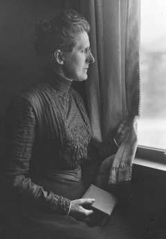
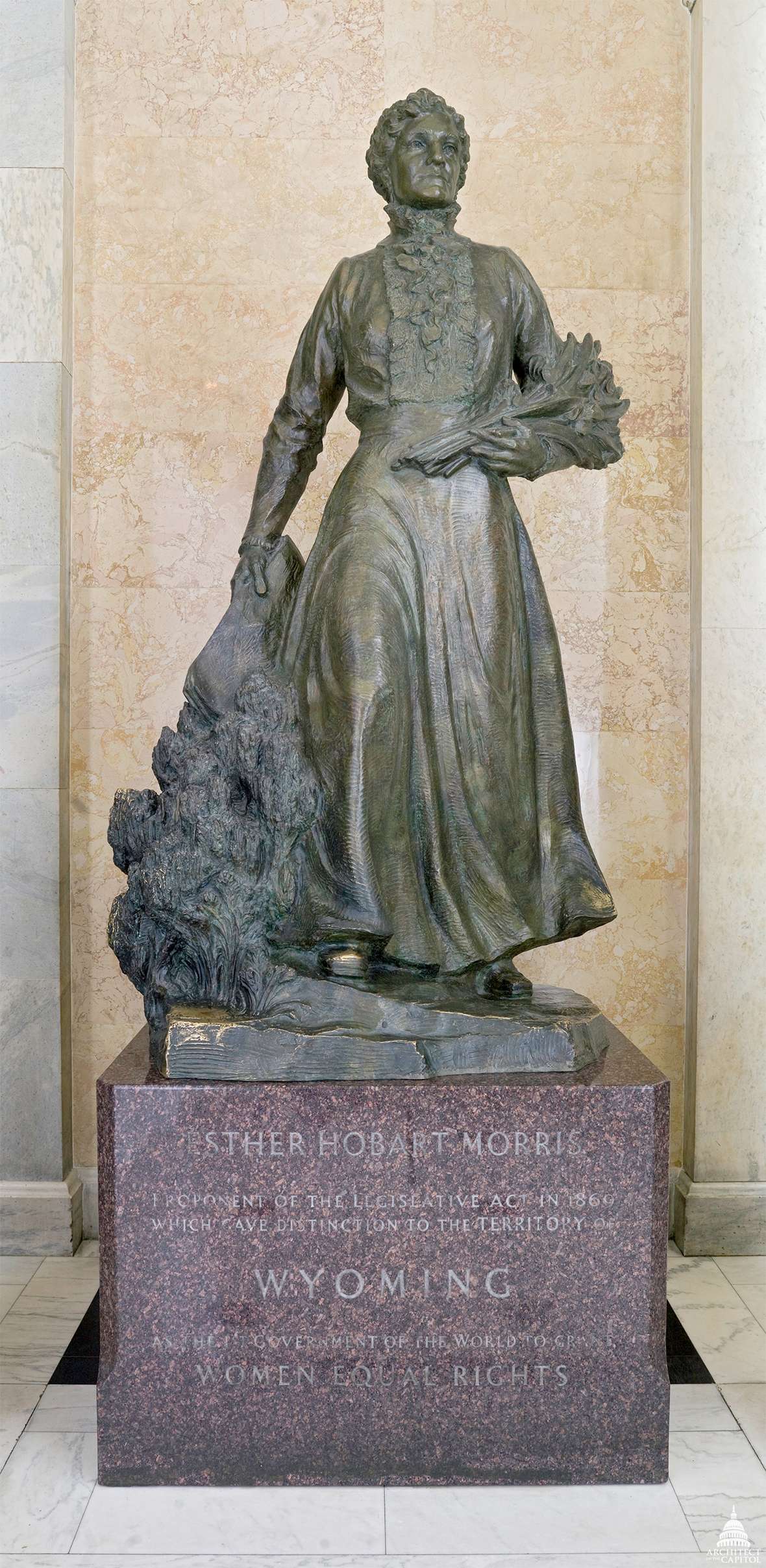
The first Wyoming Territory Legislative Assembly did pass a law on Dec. 1, 1869 providing limited additional protection. It became illegal for any person to offer for sale any elk, deer, antelope or “mountain sheep” between February and August. The law imposed a fine of $50 for any violation.

No enforcement mechanism

But there was no specific enforcement mechanism. And the law did little to stop wanton killing, mainly for hides and meat by commercial hunters. Laramie Sentinel editor James Hayford complained in early January 1870 that “loads upon loads of deer, elk and antelope” were being brought into town and much of the meat was wasted in a saturated market.

The Sentinel noted in November 1874 that Englishmen were in town and fitting out a hunting expedition around Laramie “to put in a month or two slaughtering game.” Similarly, Wyoming residents also engaged in pleasure hunting, killing large numbers of buffalo and antelope in a single outing. The Cheyenne paper reported on a hunting party in October 1875 that “killed a carload of game,” and that two men in the party killed 40-50 antelope.

In response to these types of events, the 1875 legislature amended the territory’s game laws. It closed hunting for deer, elk, “mountain sheep” and antelope from January 15 to August 15. The law also prohibited the wasting of any part of the animals taken during the open season and required that game be killed for “food purposes only.” However, as in 1869 no formal enforcement mechanism was provided.

That lack of enforcement was evident the next year when the Sentinel reported that a party of hunters were south of town slaughtering antelope for their hides. Prominent Laramie men also killed large numbers of game animals. The Cheyenne Sun noted on Sept, 12, 1877, that prominent local merchant Otto Gramm returned to Laramie after having “committed immense slaughter among elk and deer.” In 1878, Gramm was at it again along with banker Edward Ivinson, Louis Miller and William Root who returned to town from a hunt on which they killed “loads of game.”

Citizens take a stand

The effect on game herds, especially by the hide and meat hunters, eventually prompted citizens to take a stand against the depredation. The Nov. 18, 1881, Laramie Sentinel voiced their sentiment clearly.

Noting that there was a growing conviction that something needed to be done, the paper called on the legislature to take up the issue. Likely written by editor Hayford, the article notes, “If our laws for the protection of game are not sufficient for the purpose, right now is the time to call the attention of our legislators to its defects and have them remedied.” It also demanded the laws be enforced and violators punished.

Early the next year the Cheyenne Leader printed a similar column. It aimed specifically at men who had come up from Texas and were killing game only for their hides. These “hide grubbers” as the paper called them, could be stopped, the paper claimed, by prohibiting the sale or purchase of any untanned hides of deer and elk.

The Carbon County Journal followed suit, placing most of the blame on the “skin hunters” but also drew attention to the number of Englishmen who were killing large numbers of game, apparently for sport. Additionally, it called for game wardens to be hired to enforce the game laws. All three papers noted that Wyoming sportsmen were not to blame as they tended to kill only bucks and bulls, allowing the herd to replenish naturally.

Those efforts bore only limited fruit in the legislature’s next session. On March 9, 1882, the legislature passed an act that made a major revision to the hunting season, limiting it to August 1 to November 15. Additionally, the purchase of untanned hides was prohibited. Yet no limits were set on the number of animals that could be killed for personal consumption and no steps were taken toward enforcement.

The following year, Wyoming hunters made an abortive effort to band together to stop the slaughter. On March 1, 1883, the Laramie Boomerang reported that a group of men had formed the Laramie Game Protective Association of Wyoming Territory.

A similar association was formed in Cheyenne. This group published a letter from the governor of Montana to its president, area rancher Harry Oelrichs, calling for the protection of game in Yellowstone. Neither association, unfortunately, appears to have taken concrete steps beyond initial organization.

Wyoming Territory and, in its early years, the state of Wyoming enacted a series of laws that did little to curb the wanton killing of game. Here, a pair of hunters pose with their take—and a living pet—around 1900. J.E. Stimson photo, Wyoming State Archives.

Uncontrolled killing continues

The killing continued unabated. In November of that same year, the Laramie Boomerang noted three market hunters killed “three ton” of elk in the northern Laramie Range and two others killed an additional “5,000 pounds” in the Medicine Bow Mountains. And that was elk only—the total did not include the deer and antelope they killed. Meanwhile, newspapers in both Laramie and Cheyenne continued to carry grocery store ads offering game for sale.

The situation continued to worsen. In October 1885, the Laramie Boomerang issued another call for better game-protection laws. Noting that a “legitimate hunt” is a good thing, and after criticizing hide hunters the article concluded, “It will be but a short time until the bear, the deer and the antelope will disappear, as has the buffalo, unless some steps are taken to prevent a wholesale slaughter, which is now the rule.”

First limits on game harvest; game detectives authorized

When the legislature convened in January 1886, its members took three important steps. First, no non-resident of the territory could hunt any big game at any time. Second, hunters were finally required to limit the number of animals they killed. Although still high at two per day, at least it was a start. Finally, a formal mechanism for enforcement was instituted. County stock detectives, authorized beginning in 1873, were also designated “game detectives” and empowered to enforce game laws.

But having a law on the books does not necessarily convert to action. A search of contemporaneous newspapers lists a George Lambert as Albany County stock detective at the time, though it is unclear how or even if he exercised his new authority. No reports of violations or arrests are to be found.

In fact, newspaper accounts from far western Albany County in January 1887 noted that large numbers of game animals were still being killed and sent to markets in Laramie. Similarly, the new legal open season for hunting, September 1 to January 1, was ignored when it was reported that two Laramie men killed six antelope in July with no repercussions.

Blatant violations appear to have been common. In June 1888, the Saratoga Lyre noted “Elk, deer and antelope can be killed within twenty miles of Saratoga in any quantities desired.” Antelope were especially vulnerable. The Laramie Boomerang reported in October 1888 that a group of hunters killed 100 antelope. Worse, the paper also reported the men only kept the “saddle meat”—the part of the animal corresponding to where a saddle covers a horse—and left the rest to rot.

The 1890 legislature enacted further limits on the number of large game animals hunters could kill. A limit of three per week replaced the earlier two-per-day number. Buffalo hunting was suspended for 10 years, even though there were no buffalo to hunt. Additionally, the legislature removed the authority of stock detectives to enforce game laws and instead empowered any county constable to do so. This theoretically increased the likelihood of punishing hunters for game violations.

At the time there were one stock detective in Albany County and 20 elected constables. As earlier, however, there is little or no evidence of enforcement at the time.

A list of new game-protection provisions from the territorial statutes of 1886. Wyoming Territorial Statutes.

State game warden created; licenses required for non-resident hunters

Finally, in 1895, some important changes came about. The state fish commissioner was also designated to be the state game warden and given the authority to arrest without warrant anyone violating state game laws. The legislature also allowed for the appointment of deputy game wardens.

The prohibition on hunting buffalo was extended until 1905. Non-residents were again allowed to hunt in the state, but first had to buy a hunting license from the justice of the peace in the county where they would hunt. The hunting season was shortened to September through November and the law allowed the killing of male animals only.

The first reported arrest for a violation occurred in October 1897 when Deputy Game Warden Joseph Nelson arrested a Chicago man for killing an elk in Uinta County without a license. In 1899 the first state game warden, Albert Nelson, was appointed separately from the fish commissioner.

According to the Wyoming Game Wardens Association, his salary was set at $1,200 per year from which he had to pay $3per day to deputy state game wardens. Despite the new rules and their enforcement, the situation continued to deteriorate into the early 1900s.

By 1906, there may have been as few as 2,000 pronghorn antelope left in Wyoming. In 1909, the legislature banned antelope hunting entirely. By the 1920s, the herds were coming back; antelope hunting was again allowed in 1927. Here, some happy hunters show off their take near Como, east of Medicine Bow, in 1929. Wyoming State Archives.

State finally takes firm control

The state legislature finally got serious about protecting game. In 1903 all persons hunting in the state were required to purchase a hunting license. The legislature passed additional restrictive laws in 1909. The hunting of antelope was prohibited for six years and elk and moose for three. The latter could only be hunted in the northern part of the state. When the seasons opened, moose hunting was further restricted to September 25 to November 30.

The situation for antelope was especially dire. In 1906, officials estimated pronghorn numbers at only 2,000—their lowest level ever. By 1908, the number was up 4,000, with 2,000 of those in Yellowstone National Park.

The restrictions achieved the intended results. Herds began to increase, slowly. Antelope were a marked success. By 1924, their population was estimated at 7,000 head, but it was becoming clearer that competition from sheep and cattle for forage on the ranges was limiting antelope recovery. In 1927, an antelope season was opened for the first time in decades. Two years later, when hunters harvested more than 6,500, leaving a herd of

26,625, the New York Times decried the hunt as a slaughter, comparing it to the slaughter of the buffalo. In the early 1930s the state again closed the season for three years, and opened it again mid-decade.

By 1957, state estimates put the herd at 100,005 and the numbers have continued to rise—to approximately 400,000 today.

Great strides have been made in Wyoming since those early days. Big game in Wyoming is now skillfully managed by the Wyoming Game and Fish Commission with the laws enforced by about 90 dedicated game wardens. Environmental impacts such as wasting disease and drought still impact game herds in Wyoming and herd sizes are managed accordingly. And this controlled hunting is economically important to Wyoming. Spending by both residents and non-residents contributes about $3 million to the state’s economy each year and supports more than 3,000 jobs.

Resources

Primary Sources

Secondary Sources

Illustrations

A Stuntman’s Jump: Parachutist Stranded for Days on Devils Tower

$
0
0

A Stuntman’s Jump: Parachutist Stranded for Days on Devils Tower

In October 1941, when Hitler ruled nearly all of Europe and Pearl Harbor was still two months away, heads turned from a raging World War to Wyoming. A 29-year-old daredevil, George Hopkins, parachuted onto Devils Tower––the nation’s first national monument––and remained there for six days of increasing press and radio pressure while officials figured out what to do.

George Hopkins wanted to show the world what could be done with a parachute. But most people just focused on the fact that he couldn't get down from Devils Tower once he’d landed on top. National Park Service photo.

According to Mary Alice Gunderson’s 1988 book, Devils Tower: Stories in Stone, Hopkins planned the parachute stunt to win a $50 bet. This wasn’t the full story, however. He wanted to set the world record for the number of parachute jumps in a day–– 30 at the time—and chose Rapid City, S.D., as the site to do so. To gain publicity for the event, Hopkins decided a single jump would suffice, says the National Park Service. He wanted to prove that a parachutist could land on a small target.

At the time, Hopkins held several U.S. records, including the most parachute jumps (2,347) and jumping from the greatest height (26,400 feet).

The Rapid City Chamber of Commerce also sponsored an airshow, with the stunt of parachuting onto Devils Tower as the “perfect” way to publicize the show, writes Gunderson. The proceeds were to fund general hospital construction in the city.

Although Hopkins had planned—on paper—his descent off of the tower, the situation quickly became rocky when South Dakota pilot Joe Quinn returned an hour after the jump to deliver ropes and climbing equipment to Hopkins. The bundle bounced off, fell fifty feet down from Hopkins and snagged on bushes on the tower’s sides. Quinn flew back to Rapid City and couldn’t be reached. Pilot Clyde Ice delivered a second rope, but Hopkins soon concluded that it was too tangled for his descent. He would have to stay the night.

After Hopkins spent the night shivering in the rain, more than a thousand spectators, photographers, and newspaper reporters flocked to the scene. Park Service officials sent rangers and climbing guides to Hopkins’s aid with rescue equipment. Hopkins hoped to parachute to the ground. But a note from Earl Brockelsby, who had bet Hopkins the $50, reached him as Ice removed the doors of his plane and prepared to drop more food: The idea was vetoed.

Although Hopkins landed accurately, his rope did not, and he was stranded. This picture shows Hopkins, at left, and his chute on top of the tower. NPS photo.
Jack Durrance (far right, leaning over the relief map) and his team plan Hopkins’s rescue in the Devils Tower visitor center. NPS photo.

While Hopkins was dropped more supplies, no plan of descent had been fully decided upon. Park officials decided to enlist the help of Ernest K. Field, a ranger from Rocky Mountain National Park, and Warren Gorrell, a licensed climbing guide from Colorado.

He stayed atop the tower for another night, sharing food with chipmunks and squirrels, says Gunderson’s book. While the third day on the tower was uneventful for Hopkins, crowds continued to increase and national newspapers featured them, buzzing about the story of “Devils Tower George.”

According to Jeanne Rogers’s 2008 book, Standing Witness: Devils Tower National Monument, a History, the stunt was completed without the approval of the National Park Service. Regional Coordinator of the NPS at the time, Edmund Rodgers, stated, “This is the kind of stunt we are not sympathetic with. We of the park service hate to jeopardize our men’s lives for a stunt somebody thought was smart.”

A cartoonist for the Chicago Tribune contrasted the trivialities of the Hopkins media frenzy with the war raging in Europe. NPS image.
A cartoonist for the Chicago Tribune contrasted the trivialities of the Hopkins media frenzy with the war raging in Europe. NPS image. Click to enlarge
Hopkins’s plight was so well known that a cartoonist could use it to show defeated presidential candidate Wendell Willkie as the Republican Party’s best hope to rescue it from its own isolationism. NPS image.
Hopkins’s plight was so well known that a cartoonist could use it to show defeated presidential candidate Wendell Willkie as the Republican Party’s best hope to rescue it from its own isolationism. NPS image. Click to enlarge

The group of officials, including Brockelsby, worked on more rescue possibilities, from a team of climbers to guide Hopkins down the tower to using the Goodyear Blimp. The blimp, however, could be used only if it would survive the rescue. This was uncertain, so Goodyear rescinded the offer. Even the Navy offered a helicopter to save Hopkins.

A rescue climb seemed the best way to go. Dartmouth College student and experienced climber Jack Durrance led the rescue mission, along with aid from Field and Gorrell. In the late 1930s, Durrance had pioneered climbing routes up Devils Tower and several in the Tetons. In 1939 he was part of a party that tried to climb K2 in the Himalayas, the world’s second highest mountain. During the crisis with Hopkins, Durrance sent a wire to volunteer himself to help aid the mission if needed.

Once summoned, Durrance and fellow Dartmouth student Merrill McLane made it to the tower on October 5th at midnight and began the rescue the next day, the sixth since the stunt.

“It’s not easy but can be done,” Durrance said in an Associated Press article, which ran in papers nationwide.

Durrance led a team up the tower at 7:30 a.m. and despite the cold, damp weather, after a few hours all eight climbers were on top of the tower enjoying lunch with Hopkins.

Rogers included an account of the rescue from Field in her book: “Hopkins, of course, was glad to see us. He seemed entirely nonchalant and not a bit worse for wear.” Field this was because of the amount of supplies dropped to Hopkins to make his days on the tower comfortable. So comfortable that it was reported that “the parachutist had settled down with a bottle of whiskey to await rescuers.” Hopkins had “requested and received” the drink “for medicinal purposes,” according to an Associated Press story which ran in the New York Daily News.

The descent from the tower began at 4:45 p.m. All climbers reached the base by 8:20 p.m. with reporters anxiously waiting to interview Hopkins. During the six days, an estimated 7,000 visitors came to see the spectacle.

“This started out as a publicity stunt, but it backfired, then wildfired,” said Brockelsby.

In addition to newspaper reports, many papers ran political cartoons featuring the incident. The Chicago Tribune, for example,published a cartoon that portrayed Europe’s frustration with Americans. An armored figure labeled “War” yells across the Atlantic at a crowd gawking up at Devils Tower: “Hey! That’s only one American in danger! Look over here and see millions dying on European battlefields!”

At the time, Nazi Germany and its ally, Italy, had conquered nearly all of Europe. Only Great Britain resisted. The United States would not enter the war until two months later, when Japan bombed Pearl Harbor.

The cartoons took on domestic politics as well—but they were a domestic politics consumed by the war. Chicago’s Evening Star published an image showing former presidential candidate Wendell Willkie attempting to lasso an elephant (representing the Republican Party) stranded on top of a Devils Tower labeled “Isolation.” Willkie had won the Republican nomination for president in 1940 over strongly isolationist candidates opposed to U.S. entry into the war. He lost the election to Franklin Roosevelt, but at the time of Hopkins’s stunt, remained the most prominent Republican in the nation—and was maintaining a high public profile advocating for U.S. aid to Britain.

As for Hopkins, he enlisted in the army once the war began. He helped train paratroopers and supervised the making of drops behind enemy lines. He also staged airshows for charity.

According to Rogers, Hopkins quit “flying and jumping” in 1958. He said that during an airshow in Mexico, “I suddenly asked myself what I was doing there. … I just landed and walked away, and I haven’t been up since.”

The June 4, 1972, Casper Star-Tribune reflected, “If the illegal stunt were to happen today, the rescue would be swift. Army helicopters have hovered over the tower (official permission was obtained beforehand) and climbers now climb the tower in about four hours.”

The article also noted that the Park Service’s prime concern was that others may try stunts similar to Hopkins’s but “everyone seemed to respect the Tower too much to give a repeat performance.”

At an airshow in Mexico in 1958, Hopkins said later,

Resources

Primary Sources

Secondary Sources

Illustrations

  • The photos and the two cartoons from a gallery of images of and about George Hopkins on the National Parks Service’s Devils Tower website. Used with thanks.

Esther Hobart Morris, Justice of the Peace and Icon of Women's Rights

$
0
0

Esther Hobart Morris, Justice of the Peace and Icon of Women's Rights

In late 1869, the territory of Wyoming was ahead of the rest of the United States in its strides for gender equality. Fifty years before the passage of the 19th amendment to the U.S. Constitution, women in the territory were granted the right to vote and, beginning with Esther Morris, the territory’s first female justice of the peace, to hold public office.

Esther Hobart Morris was in her late 50s when she was appointed justice of the peace in South Pass City, Wyoming Territory, in 1870. '[I]n performing these duties I do not know as I have neglected my family any more than in ordinary shopping,' she wrote the following year, 'and I must admit that I have been better paid for the services rendered than for any I have ever performed.' Wikipedia.

While Morris is notable because of her excellent performance in this office and her advocacy for women’s suffrage both in the territory and, later, around the nation, much of her fame comes from something she almost certainly didn’t do. Long after Morris’s death, Fremont County legislator Herman Nickerson and University of Wyoming Professor Grace Hebard claimed that Morris deserved credit for effective lobbying in 1869 that resulted in the introduction of the women’s suffrage bill at the territorial legislature. This, however, seems not to have been what happened.

Born Esther Hobart McQuigg, in Tioga County, New York, on Aug. 8, 1814, she was orphaned at age 11 and apprenticed to a seamstress. She then, according to a brief biography at the website of the U.S. Capitol, became a successful hat-maker and businesswoman. In 1841, she married civil engineer Artemus Slack and gave birth to her first child, Edward Archibald or “Archy,” a year later.

Three years after the wedding, her husband died and Morris moved to Peru, Ill. to settle his estate. Doing this, she faced difficulties as women were not allowed to own or inherit property, the Architect of the Capitol writes. She re-married in 1850 to local merchant John Morris and gave birth to twin boys, Robert and Edward. In 1869, the family moved to gold-rush boom town South Pass City in the new Wyoming Territory, where John Morris opened a saloon.

The “terror of all rogues”

Esther Morris had been living in South Pass City for less than a year before her appointment as justice of the peace in early 1870 at the age of 55. During her eight and a half months in office as a judge, she heard nearly thirty cases.

Wyoming Territorial Secretary Edwin M. Lee wrote later that Morris’s court sessions were “characterized by a degree of gravity and decorum rarely exhibited in the judicature of border precincts.” He also said that during her administration, an “improvement in the tone of public morals was noticeable.”

An April 1870 piece in Frank Leslie’s Illustrated Newspaper—a national publication—about Morris’s first day in the position focused, first, on her clothing. She wore “a calico gown, worsted breakfast-shawl, green ribbons in her hair, and a green neck-tie.” Later, however, the newspaper noted that Morris offered “infinite delight to all lovers of peace and virtue” and nicknamed her the “terror of all rogues.”

In January 1871, Morris was invited to a national women’s suffrage convention in Washington, D.C. but did not attend. Instead, she wrote a letter to prominent suffragist Isabella Beecher Hooker which was read aloud before the convention. She wrote that her appointment, due to the circumstances in the political climate, “transpired to make [her] position as a justice of the peace a test of a woman’s ability to hold public office.” She also wrote that she felt that her work was “satisfactory” though she regretted that she was “not better qualified to fill the position. Like all pioneers,” she noted, “I labored more in faith and hope.”

By 1890, when she was 75, Morris was well known in Wyoming as an advocate of woman suffrage. In statehood celebrations that July, she presented the flag of the new state to Gov. Francis Warren on behalf of the women of Wyoming. She died at 87 on April 2, 1902, in Cheyenne.

South Pass City in 1870. When Morris served there as justice of the peace, it was still a mining camp made up mostly of men who spent most of their social time in saloons. William Henry Jackson photo, USGS.

A reputation grows

More than seventeen years after her death, however, her reputation suddenly began to grow.

Herman Nickerson, who had been one of the early pioneers of South Pass City and later served many years as a state legislator representing Fremont County, published in the Lander-based Wyoming State Journal his first-hand account of a supposed tea party.

Longtime Fremont County legislator Herman Nickerson and University of Wyoming Prof. Grace Raymond Hebard marked a great many historic sites around the state. American Heritage Center.

According to Nickerson, Morris hosted a tea party in 1869 for South Pass City’s two candidates for Wyoming’s territorial council––William Bright and Nickerson himself. In front of a crowd of dozens of people, Morris supposedly extracted promises from both men that whichever of them won the seat would introduce a women’s suffrage bill to the new council. Bright was elected, proposed the bill and on Dec. 10, 1869, Territorial Gov. John Campbell signed it into law

“[T]o Mrs. Esther Morris,” Nickerson wrote, “is due the credit and honor of advocating and originating women's suffrage in the United States.” He explained that “there were about forty ladies and gentlemen present” at the party.

At the end of his account, he noted that he did not write it for “political purposes” but “to correct historical misstatements.”

But Nickerson appears to have been making some misstatements of his own. His account in the Wyoming State Journal implies that only he, the Republican, and Bright, the Democrat, were running for a single seat on the territorial council. In fact, seven candidates were running from Sweetwater County, where South Pass City was located at the time, for three seats in the upper house in the new territory’s legislative body. Bright was the third highest vote-getter with 747 votes, and so won a seat on the council. Nickerson came in fifth, and did not.

Bright and all the members of both houses of that first territorial legislature were Democrats. One reason the suffrage bill succeeded may have been their desire to embarrass the governor, a Republican. But he surprised them by signing the bill.

There is no record of any meeting between Morris and Bright before the election. After the bill was passed, however, Morris and her son did pay a call on Bright back in South Pass City, to thank him for his efforts. The son, Robert Morris, wrote a letter about the visit to The Revolution, a weekly magazine that advocated for women’s rights.

While she was alive, Morris credited Bright with passage of the bill. In her 1871 letter to Hooker, she wrote that “to William H. Bright belongs the honor of presenting the woman suffrage bill.” In that letter, too, there was no mention of a tea party.

Herman Nickerson and Grace Raymond Hebard put up a marker in South Pass City in 1920 naming Esther Morris as the 'author of female suffrage in Wyoming.' An early version, left, and Nickerson, right, with a later version. American Heritage Center.

Nickerson and Hebard

While Morris did not credit herself for the passage of the suffrage bill, others, long after she and Bright had both passed away, claimed it for her.

After Nickerson’s account was published, University of Wyoming professor and historian Grace Raymond Hebard rallied by his side, hoping to credit Morris for the introduction of the bill. Nickerson and Hebard were friends, and had spent many days and miles marking historical sites around Wyoming.

He may have been looking to advance the status of Wyoming’s Republican party at a time when women were 18 months away from winning the vote nationwide.Nickerson, that is, may have been hoping to extend some credit for the passage of the original bill to his own party.

For her part, Hebard was a staunch supporter of women’s rights and Esther Morris made a convincing hero. Contemporary historians now agree, however, that Hebard made things up from time to time. Historian Virginia Scharff labels Hebard a “self-described feminist” who did everything she could to “stake women’s claim to space, to historical significance.”

Grace Raymond Hebard in an undated photo. She spread H. G. Nickerson’s story of Esther Morris’s tea party widely after he published it in 1920, and it continued to spread widely long after her death. American Heritage Center.

Hebard clearly championed Morris as the “Mother of Woman Suffrage.” According to Hebard, Morris and Bright held discussions about women’s rights around fireplaces in their homes. Hebard credited these conversations with giving Bright the inspiration and the final courage to introduce the women’s suffrage bill. In later stories Hebard changed the tea party into a dinner party.

In 1920, Hebard and Nickerson had a stone marker erected in South Pass City memorializing the “Site of Office and Home of Esther Morris, First Woman Justice of the Peace, Author of Female Suffrage in Wyoming.”

The tea-party story continues

Though no contemporary records document the tea party, longtime women’s suffrage leader and president of the National American Women’s Suffrage Association Carrie Chapman Catt, in her Women's Suffrage and Politics; the Inner Story of the Suffrage Movement, published in 1923,writes that Morris invited all candidates for the council and persuasively presented “the woman’s case.” Each candidate then pledged to support a suffrage bill if elected. Catt and Hebard were frequent correspondents.

In Morris’s obituary in the Cheyenne Leader,there was no mention of her role in the suffrage movement. The piece, however, was later reprinted as a pamphlet with new additions saying that Morris was “instrumental in securing the passage of the law.”

In 1953, Wyoming’s U.S. senator, Lester Hunt, proposed that a statue of Morris be erected in the National Statuary Hall in Washington D.C. States were each allowed two statues; Morris was to be Wyoming’s first. University of Wyoming History Professor T.A. Larson objected to the decision, not believing the tea party had happened. Larson wrote in his History of Wyoming that one who introduces a bill “normally” gets credit for it and that Bright was clearly credited when he was alive.

In 1960, a statue of “Mother Morris” was erected in Statuary Hall at the U.S. Capitol. To this day, she is one of only nine women in the hall. This statue, to Larson, was placed “thanks to the upstaging” of Bright by Morris. On the Capitol’s website, The Architect of the Capitol notes only that with the statue, “Morris is honored as a pioneer for women’s suffrage.”

In 1963, a duplicate of the statue was erected in front of the Wyoming State Capitol in Cheyenne. When the Capitol reopened in 2019 after a four-year remodel, the Morris statue had been moved inside, to the Capitol Extension, the expanded underground space between the Capitol and the Herschler building.

“Future authors, teachers [and] historians,” writes longtime Wyoming historian Rick Ewig, “need to follow Esther’s lead, and not award her credit” for passage of the suffrage bill, “which she did not claim, and for which there is no supporting evidence.” Ewig’s article in the Winter 2006 Annals of Wyoming is one of the main sources for this piece.

The heroic Avard Fairbanks statue of Esther Morris at the U.S. Capitol was installed in 1960, and remains there. A duplicate stood for decades in front of the Wyoming Capitol. As part of the 2019 remodel of the building the sculpture was moved underground to the Capitol Extension between the Capitol and the Herschler Building. Architect of the Capitol.

Resources

Primary Sources

  • Catt, Carrie Chapman. Woman Suffrage and Politics, the Inner Story of the Suffrage Movement. Buffalo, N.Y.: Hein, 2005, 75.

Secondary Sources

Illustrations

  • The portrait of Esther Hobart Morris is from Wikipedia. Used with thanks.
  • The 1870 William Henry Jackson photo of South Pass City is from the U.S. Geological Survey’s online photo library. Used with thanks.
  • The photos of Grace Hebard, Herman Nickerson and the two markers at South Pass City are all from the American Heritage Center at the University of Wyoming. Used with permission and thanks.
  • The photo of the Esther Morris statue is from the Architect of the Capitol’s website. Used with thanks.

A Stuntman’s Jump: Parachutist Stranded for Days on Devils Tower

$
0
0

A Stuntman’s Jump: Parachutist Stranded for Days on Devils Tower

Abby Dotterer Tuesday, July 23, 2019

In October 1941, when Hitler ruled nearly all of Europe and Pearl Harbor was still two months away, heads turned from a raging World War to Wyoming. A 29-year-old daredevil, George Hopkins, parachuted onto Devils Tower––the nation’s first national monument––and remained there for six days of increasing press and radio pressure while officials figured out what to do.

George Hopkins wanted to show the world what could be done with a parachute. But most people just focused on the fact that he couldn't get down from Devils Tower once he’d landed on top. National Park Service photo.

According to Mary Alice Gunderson’s 1988 book, Devils Tower: Stories in Stone, Hopkins planned the parachute stunt to win a $50 bet. This wasn’t the full story, however. He wanted to set the world record for the number of parachute jumps in a day–– 30 at the time—and chose Rapid City, S.D., as the site to do so. To gain publicity for the event, Hopkins decided a single jump would suffice, says the National Park Service. He wanted to prove that a parachutist could land on a small target.

At the time, Hopkins held several U.S. records, including the most parachute jumps (2,347) and jumping from the greatest height (26,400 feet).

The Rapid City Chamber of Commerce also sponsored an airshow, with the stunt of parachuting onto Devils Tower as the “perfect” way to publicize the show, writes Gunderson. The proceeds were to fund general hospital construction in the city.

Although Hopkins had planned—on paper—his descent off of the tower, the situation quickly became rocky when South Dakota pilot Joe Quinn returned an hour after the jump to deliver ropes and climbing equipment to Hopkins. The bundle bounced off, fell fifty feet down from Hopkins and snagged on bushes on the tower’s sides. Quinn flew back to Rapid City and couldn’t be reached. Pilot Clyde Ice delivered a second rope, but Hopkins soon concluded that it was too tangled for his descent. He would have to stay the night.

After Hopkins spent the night shivering in the rain, more than a thousand spectators, photographers, and newspaper reporters flocked to the scene. Park Service officials sent rangers and climbing guides to Hopkins’s aid with rescue equipment. Hopkins hoped to parachute to the ground. But a note from Earl Brockelsby, who had bet Hopkins the $50, reached him as Ice removed the doors of his plane and prepared to drop more food: The idea was vetoed.

Although Hopkins landed accurately, his rope did not, and he was stranded. This picture shows Hopkins, at left, and his chute on top of the tower. NPS photo. Jack Durrance (far right, leaning over the relief map) and his team plan Hopkins’s rescue in the Devils Tower visitor center. NPS photo.

While Hopkins was dropped more supplies, no plan of descent had been fully decided upon. Park officials decided to enlist the help of Ernest K. Field, a ranger from Rocky Mountain National Park, and Warren Gorrell, a licensed climbing guide from Colorado.

He stayed atop the tower for another night, sharing food with chipmunks and squirrels, says Gunderson’s book. While the third day on the tower was uneventful for Hopkins, crowds continued to increase and national newspapers featured them, buzzing about the story of “Devils Tower George.”

According to Jeanne Rogers’s 2008 book, Standing Witness: Devils Tower National Monument, a History, the stunt was completed without the approval of the National Park Service. Regional Coordinator of the NPS at the time, Edmund Rodgers, stated, “This is the kind of stunt we are not sympathetic with. We of the park service hate to jeopardize our men’s lives for a stunt somebody thought was smart.”

A cartoonist for the Chicago Tribune contrasted the trivialities of the Hopkins media frenzy with the war raging in Europe. NPS image. Click to enlarge Hopkins’s plight was so well known that a cartoonist could use it to show defeated presidential candidate Wendell Willkie as the Republican Party’s best hope to rescue it from its own isolationism. NPS image. Click to enlarge

The group of officials, including Brockelsby, worked on more rescue possibilities, from a team of climbers to guide Hopkins down the tower to using the Goodyear Blimp. The blimp, however, could be used only if it would survive the rescue. This was uncertain, so Goodyear rescinded the offer. Even the Navy offered a helicopter to save Hopkins.

A rescue climb seemed the best way to go. Dartmouth College student and experienced climber Jack Durrance led the rescue mission, along with aid from Field and Gorrell. In the late 1930s, Durrance had pioneered climbing routes up Devils Tower and several in the Tetons. In 1939 he was part of a party that tried to climb K2 in the Himalayas, the world’s second highest mountain. During the crisis with Hopkins, Durrance sent a wire to volunteer himself to help aid the mission if needed.

Once summoned, Durrance and fellow Dartmouth student Merrill McLane made it to the tower on October 5th at midnight and began the rescue the next day, the sixth since the stunt.

“It’s not easy but can be done,” Durrance said in an Associated Press article, which ran in papers nationwide.

Durrance led a team up the tower at 7:30 a.m. and despite the cold, damp weather, after a few hours all eight climbers were on top of the tower enjoying lunch with Hopkins.

Rogers included an account of the rescue from Field in her book: “Hopkins, of course, was glad to see us. He seemed entirely nonchalant and not a bit worse for wear.” Field this was because of the amount of supplies dropped to Hopkins to make his days on the tower comfortable. So comfortable that it was reported that “the parachutist had settled down with a bottle of whiskey to await rescuers.” Hopkins had “requested and received” the drink “for medicinal purposes,” according to an Associated Press story which ran in the New York Daily News.

The descent from the tower began at 4:45 p.m. All climbers reached the base by 8:20 p.m. with reporters anxiously waiting to interview Hopkins. During the six days, an estimated 7,000 visitors came to see the spectacle.

“This started out as a publicity stunt, but it backfired, then wildfired,” said Brockelsby.

In addition to newspaper reports, many papers ran political cartoons featuring the incident. The Chicago Tribune, for example,published a cartoon that portrayed Europe’s frustration with Americans. An armored figure labeled “War” yells across the Atlantic at a crowd gawking up at Devils Tower: “Hey! That’s only one American in danger! Look over here and see millions dying on European battlefields!”

At the time, Nazi Germany and its ally, Italy, had conquered nearly all of Europe. Only Great Britain resisted. The United States would not enter the war until two months later, when Japan bombed Pearl Harbor.

The cartoons took on domestic politics as well—but they were a domestic politics consumed by the war. Chicago’s Evening Star published an image showing former presidential candidate Wendell Willkie attempting to lasso an elephant (representing the Republican Party) stranded on top of a Devils Tower labeled “Isolation.” Willkie had won the Republican nomination for president in 1940 over strongly isolationist candidates opposed to U.S. entry into the war. He lost the election to Franklin Roosevelt, but at the time of Hopkins’s stunt, remained the most prominent Republican in the nation—and was maintaining a high public profile advocating for U.S. aid to Britain.

As for Hopkins, he enlisted in the army once the war began. He helped train paratroopers and supervised the making of drops behind enemy lines. He also staged airshows for charity.

According to Rogers, Hopkins quit “flying and jumping” in 1958. He said that during an airshow in Mexico, “I suddenly asked myself what I was doing there. … I just landed and walked away, and I haven’t been up since.”

The June 4, 1972, Casper Star-Tribune reflected, “If the illegal stunt were to happen today, the rescue would be swift. Army helicopters have hovered over the tower (official permission was obtained beforehand) and climbers now climb the tower in about four hours.”

The article also noted that the Park Service’s prime concern was that others may try stunts similar to Hopkins’s but “everyone seemed to respect the Tower too much to give a repeat performance.”

At an airshow in Mexico in 1958, Hopkins said later,

Resources

Primary Sources

Secondary Sources

Illustrations

  • The photos and the two cartoons from a gallery of images of and about George Hopkins on the National Parks Service’s Devils Tower website. Used with thanks.

Esther Hobart Morris, Justice of the Peace and Icon of Women's Rights

$
0
0

Esther Hobart Morris, Justice of the Peace and Icon of Women's Rights

Abby Dotterer Wednesday, September 4, 2019

In late 1869, the territory of Wyoming was ahead of the rest of the United States in its strides for gender equality. Fifty years before the passage of the 19th amendment to the U.S. Constitution, women in the territory were granted the right to vote and, beginning with Esther Morris, the territory’s first female justice of the peace, to hold public office.

Esther Hobart Morris was in her late 50s when she was appointed justice of the peace in South Pass City, Wyoming Territory, in 1870. '[I]n performing these duties I do not know as I have neglected my family any more than in ordinary shopping,' she wrote the following year, 'and I must admit that I have been better paid for the services rendered than for any I have ever performed.' Wikipedia.

While Morris is notable because of her excellent performance in this office and her advocacy for women’s suffrage both in the territory and, later, around the nation, much of her fame comes from something she almost certainly didn’t do. Long after Morris’s death, Fremont County legislator Herman Nickerson and University of Wyoming Professor Grace Hebard claimed that Morris deserved credit for effective lobbying in 1869 that resulted in the introduction of the women’s suffrage bill at the territorial legislature. This, however, seems not to have been what happened.

Born Esther Hobart McQuigg, in Tioga County, New York, on Aug. 8, 1814, she was orphaned at age 11 and apprenticed to a seamstress. She then, according to a brief biography at the website of the U.S. Capitol, became a successful hat-maker and businesswoman. In 1841, she married civil engineer Artemus Slack and gave birth to her first child, Edward Archibald or “Archy,” a year later.

Three years after the wedding, her husband died and Morris moved to Peru, Ill. to settle his estate. Doing this, she faced difficulties as women were not allowed to own or inherit property, the Architect of the Capitol writes. She re-married in 1850 to local merchant John Morris and gave birth to twin boys, Robert and Edward. In 1869, the family moved to gold-rush boom town South Pass City in the new Wyoming Territory, where John Morris opened a saloon.

The “terror of all rogues”

Esther Morris had been living in South Pass City for less than a year before her appointment as justice of the peace in early 1870 at the age of 55. During her eight and a half months in office as a judge, she heard nearly thirty cases.

Wyoming Territorial Secretary Edwin M. Lee wrote later that Morris’s court sessions were “characterized by a degree of gravity and decorum rarely exhibited in the judicature of border precincts.” He also said that during her administration, an “improvement in the tone of public morals was noticeable.”

An April 1870 piece in Frank Leslie’s Illustrated Newspaper—a national publication—about Morris’s first day in the position focused, first, on her clothing. She wore “a calico gown, worsted breakfast-shawl, green ribbons in her hair, and a green neck-tie.” Later, however, the newspaper noted that Morris offered “infinite delight to all lovers of peace and virtue” and nicknamed her the “terror of all rogues.”

In January 1871, Morris was invited to a national women’s suffrage convention in Washington, D.C. but did not attend. Instead, she wrote a letter to prominent suffragist Isabella Beecher Hooker which was read aloud before the convention. She wrote that her appointment, due to the circumstances in the political climate, “transpired to make [her] position as a justice of the peace a test of a woman’s ability to hold public office.” She also wrote that she felt that her work was “satisfactory” though she regretted that she was “not better qualified to fill the position. Like all pioneers,” she noted, “I labored more in faith and hope.”

By 1890, when she was 75, Morris was well known in Wyoming as an advocate of woman suffrage. In statehood celebrations that July, she presented the flag of the new state to Gov. Francis Warren on behalf of the women of Wyoming. She died at 87 on April 2, 1902, in Cheyenne.

South Pass City in 1870. When Morris served there as justice of the peace, it was still a mining camp made up mostly of men who spent most of their social time in saloons. William Henry Jackson photo, USGS.

A reputation grows

More than seventeen years after her death, however, her reputation suddenly began to grow.

Herman Nickerson, who had been one of the early pioneers of South Pass City and later served many years as a state legislator representing Fremont County, published in the Lander-based Wyoming State Journal his first-hand account of a supposed tea party.

Longtime Fremont County legislator Herman Nickerson and University of Wyoming Prof. Grace Raymond Hebard marked a great many historic sites around the state. American Heritage Center.

According to Nickerson, Morris hosted a tea party in 1869 for South Pass City’s two candidates for Wyoming’s territorial council––William Bright and Nickerson himself. In front of a crowd of dozens of people, Morris supposedly extracted promises from both men that whichever of them won the seat would introduce a women’s suffrage bill to the new council. Bright was elected, proposed the bill and on Dec. 10, 1869, Territorial Gov. John Campbell signed it into law

“[T]o Mrs. Esther Morris,” Nickerson wrote, “is due the credit and honor of advocating and originating women's suffrage in the United States.” He explained that “there were about forty ladies and gentlemen present” at the party.

At the end of his account, he noted that he did not write it for “political purposes” but “to correct historical misstatements.”

But Nickerson appears to have been making some misstatements of his own. His account in the Wyoming State Journal implies that only he, the Republican, and Bright, the Democrat, were running for a single seat on the territorial council. In fact, seven candidates were running from Sweetwater County, where South Pass City was located at the time, for three seats in the upper house in the new territory’s legislative body. Bright was the third highest vote-getter with 747 votes, and so won a seat on the council. Nickerson came in fifth, and did not.

Bright and all the members of both houses of that first territorial legislature were Democrats. One reason the suffrage bill succeeded may have been their desire to embarrass the governor, a Republican. But he surprised them by signing the bill.

There is no record of any meeting between Morris and Bright before the election. After the bill was passed, however, Morris and her son did pay a call on Bright back in South Pass City, to thank him for his efforts. The son, Robert Morris, wrote a letter about the visit to The Revolution, a weekly magazine that advocated for women’s rights.

While she was alive, Morris credited Bright with passage of the bill. In her 1871 letter to Hooker, she wrote that “to William H. Bright belongs the honor of presenting the woman suffrage bill.” In that letter, too, there was no mention of a tea party.

Herman Nickerson and Grace Raymond Hebard put up a marker in South Pass City in 1920 naming Esther Morris as the 'author of female suffrage in Wyoming.' An early version, left, and Nickerson, right, with a later version. American Heritage Center.

Nickerson and Hebard

While Morris did not credit herself for the passage of the suffrage bill, others, long after she and Bright had both passed away, claimed it for her.

After Nickerson’s account was published, University of Wyoming professor and historian Grace Raymond Hebard rallied by his side, hoping to credit Morris for the introduction of the bill. Nickerson and Hebard were friends, and had spent many days and miles marking historical sites around Wyoming.

He may have been looking to advance the status of Wyoming’s Republican party at a time when women were 18 months away from winning the vote nationwide.Nickerson, that is, may have been hoping to extend some credit for the passage of the original bill to his own party.

For her part, Hebard was a staunch supporter of women’s rights and Esther Morris made a convincing hero. Contemporary historians now agree, however, that Hebard made things up from time to time. Historian Virginia Scharff labels Hebard a “self-described feminist” who did everything she could to “stake women’s claim to space, to historical significance.”

Grace Raymond Hebard in an undated photo. She spread H. G. Nickerson’s story of Esther Morris’s tea party widely after he published it in 1920, and it continued to spread widely long after her death. American Heritage Center.

Hebard clearly championed Morris as the “Mother of Woman Suffrage.” According to Hebard, Morris and Bright held discussions about women’s rights around fireplaces in their homes. Hebard credited these conversations with giving Bright the inspiration and the final courage to introduce the women’s suffrage bill. In later stories Hebard changed the tea party into a dinner party.

In 1920, Hebard and Nickerson had a stone marker erected in South Pass City memorializing the “Site of Office and Home of Esther Morris, First Woman Justice of the Peace, Author of Female Suffrage in Wyoming.”

The tea-party story continues

Though no contemporary records document the tea party, longtime women’s suffrage leader and president of the National American Women’s Suffrage Association Carrie Chapman Catt, in her Women's Suffrage and Politics; the Inner Story of the Suffrage Movement, published in 1923,writes that Morris invited all candidates for the council and persuasively presented “the woman’s case.” Each candidate then pledged to support a suffrage bill if elected. Catt and Hebard were frequent correspondents.

In Morris’s obituary in the Cheyenne Leader,there was no mention of her role in the suffrage movement. The piece, however, was later reprinted as a pamphlet with new additions saying that Morris was “instrumental in securing the passage of the law.”

In 1953, Wyoming’s U.S. senator, Lester Hunt, proposed that a statue of Morris be erected in the National Statuary Hall in Washington D.C. States were each allowed two statues; Morris was to be Wyoming’s first. University of Wyoming History Professor T.A. Larson objected to the decision, not believing the tea party had happened. Larson wrote in his History of Wyoming that one who introduces a bill “normally” gets credit for it and that Bright was clearly credited when he was alive.

In 1960, a statue of “Mother Morris” was erected in Statuary Hall at the U.S. Capitol. To this day, she is one of only nine women in the hall. This statue, to Larson, was placed “thanks to the upstaging” of Bright by Morris. On the Capitol’s website, The Architect of the Capitol notes only that with the statue, “Morris is honored as a pioneer for women’s suffrage.”

In 1963, a duplicate of the statue was erected in front of the Wyoming State Capitol in Cheyenne. When the Capitol reopened in 2019 after a four-year remodel, the Morris statue had been moved inside, to the Capitol Extension, the expanded underground space between the Capitol and the Herschler building.

“Future authors, teachers [and] historians,” writes longtime Wyoming historian Rick Ewig, “need to follow Esther’s lead, and not award her credit” for passage of the suffrage bill, “which she did not claim, and for which there is no supporting evidence.” Ewig’s article in the Winter 2006 Annals of Wyoming is one of the main sources for this piece.

The heroic Avard Fairbanks statue of Esther Morris at the U.S. Capitol was installed in 1960, and remains there. A duplicate stood for decades in front of the Wyoming Capitol. As part of the 2019 remodel of the building the sculpture was moved underground to the Capitol Extension between the Capitol and the Herschler Building. Architect of the Capitol.

Resources

Primary Sources

  • Catt, Carrie Chapman. Woman Suffrage and Politics, the Inner Story of the Suffrage Movement. Buffalo, N.Y.: Hein, 2005, 75.

Secondary Sources

Illustrations

  • The portrait of Esther Hobart Morris is from Wikipedia. Used with thanks.
  • The 1870 William Henry Jackson photo of South Pass City is from the U.S. Geological Survey’s online photo library. Used with thanks.
  • The photos of Grace Hebard, Herman Nickerson and the two markers at South Pass City are all from the American Heritage Center at the University of Wyoming. Used with permission and thanks.
  • The photo of the Esther Morris statue is from the Architect of the Capitol’s website. Used with thanks.
Viewing all 40 articles
Browse latest View live